Neftekumsk geodata
Neftekumsk (Stavropol’ Kray) is a populated place; located in Russia in Europe/Moscow (GMT+3) time zone. With population of 27,716 people, there are 707 cities with bigger population in this country. Compared to other cities in Russia, 88.6% of cities are located further ↑North; 50% of cities are located further ←West and 85.8% of cities have higher elevation than Neftekumsk. Note1


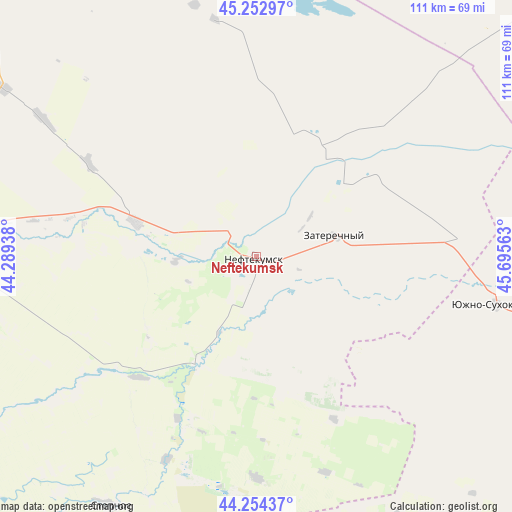
Neftekumsk GPS coordinates[2]
44° 45' 20.988" North, 44° 59' 33" East
| Map corner | latitude | longitude |
|---|---|---|
| Upper-left | 45.25297°, | 44.28938° |
| Center: | 44.75583°, | 44.9925° |
| Lower-right: | 44.25437°, | 45.69563° |
| Map W x H: | 111×111 km | = 69×69mi |
| max Lat: | 73.50819° ⇑88.6% North |
| Neftekumsk: | 44.75583° |
| min Lat: | ⇓11.4% South 41.28413° |
| min Long | Neftekumsk | max Long |
| -179.12198° | 44.9925° | 179.35046° |
| W 50%⇐ | ⇒50% E |
Elevation
Elevation of Neftekumsk is 44 m = 144 ft, and this is 158.6 m = 520 ft below average elevation for this country.
| Max E: |
2518 m = 8261 ft | 85.8% |
| Avg. | 202.6 m = 665 ft | |
| Neftekumsk | 44 m = 144 ft | |
Min E: |
-28 m = -92 ft | 14.2% |
See also: Russia elevation on elevation.city.
Geographical zone
Neftekumsk is located in North temperate zone (between Tropic of Cancer and the Arctic Circle). Distance of this Northern Tropic circle is 2370.5 km =1473 mi to South.| Distance of | km | miles | from Neftekumsk |
|---|---|---|---|
| North Pole | 5030.7 | 3125.9 | to North |
| Arctic Circle | 2424.8 | 1506.7 | to North |
| Tropic Cancer | 2370.5 | 1473 | to South |
| Equator | 4976.4 | 3092.2 | to South |


Nearby cities:
15 places around Neftekumsk: (largest is in red/bold)
• Achikulak
25.8 km =16 mi,  208°
208°
• Budënnovsk
65.3 km =40.6 mi,  272°
272°
• Irgakly
47.7 km =29.6 mi,  203°
203°
• Kara-Tyube
37.7 km =23.4 mi,  111°
111°
• Kayasula
47.9 km =29.8 mi,  179°
179°
• Levokumskoye
27.2 km =16.9 mi,  285°
285°
• Orlovka
65 km =40.4 mi,  263°
263°
• Pokoynoye
58.8 km =36.5 mi,  275°
275°
• Praskoveya
62.4 km =38.8 mi, 268°
• Pravokumskoye
27.3 km =17 mi, 273°
• Solomenskoye
78.5 km =48.8 mi,  220°
220°
• Stepnoye
62.9 km =39.1 mi, 210°
• Urozhaynoye
6.6 km =4.1 mi,  303°
303°
• Yuzhno-Sukhokumsk
52.6 km =32.7 mi,  101°
101°
• Zaterechnyy
17.6 km =10.9 mi,  76°
76°
Sources, notices
• [Note1] Compared only with cities in Russia existing in our database
• [Src1] Map data: © OpenStreetMap contributors (CC-BY-SA)
• [Src2] Other city data from geonames.org with taken over terms of usage.
• [Src3] Geographical zone / Annual Mean Temperature by Robert A. Rohde @ Wikipedia
