Verkh-Suetka geodata
Verkh-Suetka (Altai Krai) is a populated place; located in Russia in Asia/Barnaul (GMT+7) time zone. With population of 2,580 people, there are 3930 cities with bigger population in this country. Compared to other cities in Russia, 60.3% of cities are located further ↑North; 79.4% of cities are located further ←West and 53.1% of cities have higher elevation than Verkh-Suetka. Note1


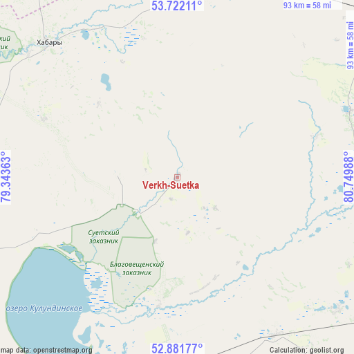
Verkh-Suetka GPS coordinates[2]
53° 18' 14.436" North, 80° 2' 48.3" East
| Map corner | latitude | longitude |
|---|---|---|
| Upper-left | 53.72211°, | 79.34363° |
| Center: | 53.30401°, | 80.04675° |
| Lower-right: | 52.88177°, | 80.74988° |
| Map W x H: | 93.4×93.4 km | = 58×58mi |
| max Lat: | 73.50819° ⇑60.3% North |
| Verkh-Suetka: | 53.30401° |
| min Lat: | ⇓39.7% South 41.28413° |
| min Long | Verkh-Suetka | max Long |
| -179.12198° | 80.04675° | 179.35046° |
| W 79.4%⇐ | ⇒20.6% E |
Elevation
Elevation of Verkh-Suetka is 138 m = 453 ft, and this is 64.6 m = 212 ft below average elevation for this country.
| Max E: |
2518 m = 8261 ft | 53.1% |
| Avg. | 202.6 m = 665 ft | |
| Verkh-Suetka | 138 m = 453 ft | |
Min E: |
-28 m = -92 ft | 46.9% |
See also: Russia elevation on elevation.city.
Geographical zone
Verkh-Suetka is located in North temperate zone (between Tropic of Cancer and the Arctic Circle). Distance of this North polar circle is 1474.3 km =916.1 mi to North.| Distance of | km | miles | from Verkh-Suetka |
|---|---|---|---|
| North Pole | 4080.2 | 2535.3 | to North |
| Arctic Circle | 1474.3 | 916.1 | to North |
| Tropic Cancer | 3320.9 | 2063.5 | to South |
| Equator | 5926.9 | 3682.8 | to South |


Nearby cities:
15 places around Verkh-Suetka: (largest is in red/bold)
• Bayevo
48.8 km =30.3 mi,  94°
94°
• Blagoveshchenka
53.7 km =33.4 mi,  192°
192°
• Gal’bshtadt
71.2 km =44.2 mi,  263°
263°
• Grishkovka
88 km =54.7 mi, 258°
• Khabary
49.3 km =30.6 mi,  316°
316°
• Krasnozërskoye
92.4 km =57.4 mi, 324°
• Kusak
74.6 km =46.4 mi, 263°
• Pankrushikha
61.8 km =38.4 mi,  18°
18°
• Podsosnovo
75.3 km =46.8 mi,  275°
275°
• Polovinnoye
73.2 km =45.5 mi,  313°
313°
• Rodino
90.2 km =56 mi,  173°
173°
• Slavgorodskoye
98.7 km =61.3 mi,  251°
251°
• Tyumentsevo
96.4 km =59.9 mi, 88°
• Ust’yanka
88.1 km =54.7 mi, 280°
• Zav’yalovo
78 km =48.5 mi,  131°
131°
Sources, notices
• [Note1] Compared only with cities in Russia existing in our database
• [Src1] Map data: © OpenStreetMap contributors (CC-BY-SA)
• [Src2] Other city data from geonames.org with taken over terms of usage.
• [Src3] Geographical zone / Annual Mean Temperature by Robert A. Rohde @ Wikipedia
