Onguday geodata
Onguday (Altai) is a populated place; located in Russia in Asia/Barnaul (GMT+7) time zone. With population of 5,406 people, there are 2468 cities with bigger population in this country. Compared to other cities in Russia, 75.8% of cities are located further ↑North; 83.8% of cities are located further ←West and 97.7% of cities have lower elevation than Onguday. Note1


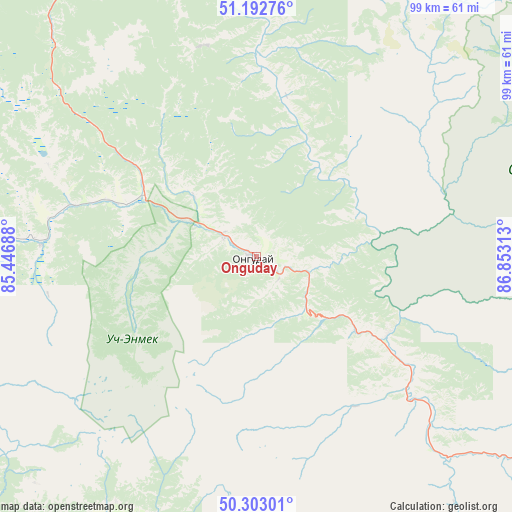
Onguday GPS coordinates[2]
50° 45' 0" North, 86° 9' 0" East
| Map corner | latitude | longitude |
|---|---|---|
| Upper-left | 51.19276°, | 85.44688° |
| Center: | 50.75°, | 86.15° |
| Lower-right: | 50.30301°, | 86.85313° |
| Map W x H: | 98.9×98.9 km | = 61.5×61.5mi |
| max Lat: | 73.50819° ⇑75.8% North |
| Onguday: | 50.75° |
| min Lat: | ⇓24.2% South 41.28413° |
| min Long | Onguday | max Long |
| -179.12198° | 86.15° | 179.35046° |
| W 83.8%⇐ | ⇒16.2% E |
Elevation
Elevation of Onguday is 839 m = 2753 ft, and this is 636.4 m = 2088 ft above average elevation for this country.
| Max E: |
2518 m = 8261 ft | 2.3% |
| Onguday | 839 m 2753 ft | |
| Avg. | 202.6 m = 665 ft | |
Min E: |
-28 m = -92 ft | 97.7% |
See also: Russia elevation on elevation.city.
Geographical zone
Onguday is located in North temperate zone (between Tropic of Cancer and the Arctic Circle). Distance of this North polar circle is 1758.3 km =1092.6 mi to North.| Distance of | km | miles | from Onguday |
|---|---|---|---|
| North Pole | 4364.2 | 2711.8 | to North |
| Arctic Circle | 1758.3 | 1092.6 | to North |
| Tropic Cancer | 3037 | 1887.1 | to South |
| Equator | 5642.9 | 3506.3 | to South |


Nearby cities:
15 places around Onguday: (largest is in red/bold)
• Chemal
74.2 km =46.1 mi,  352°
352°
• Cherga
99.8 km =62 mi,  335°
335°
• Chibit
107.9 km =67 mi,  116°
116°
• Elekmonar
79.6 km =49.5 mi, 351°
• Il’inka
105.8 km =65.7 mi,  316°
316°
• Inya
46.9 km =29.1 mi,  134°
134°
• Kamlak
102.9 km =63.9 mi, 340°
• Kupchegen
24.2 km =15 mi, 126°
• Mul’ta
65.7 km =40.8 mi,  191°
191°
• Shebalino
68.7 km =42.7 mi,  331°
331°
• Ust’-Kan
99.5 km =61.8 mi,  281°
281°
• Ust’-Koksa
65.6 km =40.8 mi,  215°
215°
• Uznezya
87.6 km =54.4 mi, 350°
• Verkh-Uymon
66.4 km =41.3 mi,  205°
205°
• Verkhniy Uymon
66.4 km =41.3 mi, 205°
Sources, notices
• [Note1] Compared only with cities in Russia existing in our database
• [Src1] Map data: © OpenStreetMap contributors (CC-BY-SA)
• [Src2] Other city data from geonames.org with taken over terms of usage.
• [Src3] Geographical zone / Annual Mean Temperature by Robert A. Rohde @ Wikipedia
