Riyadh geodata
Riyadh (Ar Riyāḑ) is a capital of a political entity; located in Saudi Arabia in Asia/Riyadh (GMT+3) time zone. With population of 4,205,961 people, there are 0 cities with bigger population in this country. Compared to other cities in Saudi Arabia, 60.8% of cities are located further ↑North; 68% of cities are located further ←West and 63.9% of cities have lower elevation than Riyadh. Note1


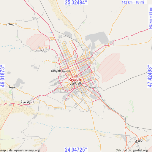
Riyadh GPS coordinates[2]
24° 41' 15.828" North, 46° 43' 18.66" East
| Map corner | latitude | longitude |
|---|---|---|
| Upper-left | 25.32494°, | 46.01873° |
| Center: | 24.68773°, | 46.72185° |
| Lower-right: | 24.04725°, | 47.42498° |
| Map W x H: | 142.1×142.1 km | = 88.3×88.3mi |
| max Lat: | 31.67252° ⇑60.8% North |
| Riyadh: | 24.68773° |
| min Lat: | ⇓39.2% South 16.57946° |
| min Long | Riyadh | max Long |
| 35.69014° | 46.72185° | 54.09599° |
| W 68%⇐ | ⇒32% E |
Elevation
Elevation of Riyadh is 612 m = 2008 ft, and this is 90.6 m = 297 ft above average elevation for this country.
| Max E: |
2385 m = 7825 ft | 36.1% |
| Riyadh | 612 m 2008 ft | |
| Avg. | 521.4 m = 1711 ft | |
Min E: |
3 m = 10 ft | 63.9% |
See also: Riyadh elevation on elevation.city.
Geographical zone
Riyadh is located in North temperate zone (between Tropic of Cancer and the Arctic Circle). Distance of this Northern Tropic circle is 139.1 km =86.4 mi to South.| Distance of | km | miles | from Riyadh |
|---|---|---|---|
| North Pole | 7262 | 4512.4 | to North |
| Arctic Circle | 4656.2 | 2893.2 | to North |
| Tropic Cancer | 139.1 | 86.4 | to South |
| Equator | 2745 | 1705.7 | to South |


Nearby cities:
15 places around Riyadh: (largest is in red/bold)
• Ad Dawādimī
236.4 km =146.9 mi,  265°
265°
• Ad Dilam
89.4 km =55.6 mi,  150°
150°
• Ain AlBaraha
297.8 km =185 mi, 271°
• Al Arţāwīyah
244.4 km =151.9 mi,  325°
325°
• Al Hufūf
298.4 km =185.4 mi,  75°
75°
• Al Kharj
85.7 km =53.3 mi,  133°
133°
• Al Majma‘ah
193.2 km =120 mi,  314°
314°
• Al Mithnab
283.1 km =175.9 mi,  297°
297°
• Al Mubarraz
299.8 km =186.3 mi,  74°
74°
• Al Muţayrifī
298.9 km =185.7 mi, 72°
• Az Zulfī
262.1 km =162.9 mi, 313°
• Marāt
134.4 km =83.5 mi,  288°
288°
• Sājir
220.9 km =137.3 mi,  284°
284°
• Tumayr
141.9 km =88.2 mi,  322°
322°
• shokhaibٍ
50.8 km =31.6 mi,  244°
244°
In other languages:
- In Spanish: Riad
- In France: Riyad
- In German: Riad
- In Italian: Riyad
- In Russian: Эр-Рияд
- In Chinese: 利雅德
Sources, notices
• [Note1] Compared only with cities in Saudi Arabia existing in our database
• [Src1] Map data: © OpenStreetMap contributors (CC-BY-SA)
• [Src2] Other city data from geonames.org with taken over terms of usage.
• [Src3] Geographical zone / Annual Mean Temperature by Robert A. Rohde @ Wikipedia
