Marāt geodata
Marāt (Ar Riyāḑ) is a populated place; located in Saudi Arabia in Asia/Riyadh (GMT+3) time zone. With population of 8,885 people, there are 73 cities with bigger population in this country. Compared to other cities in Saudi Arabia, 56.7% of cities are located further ↑North; 61.9% of cities are located further ←West and 73.2% of cities have lower elevation than Marāt. Note1


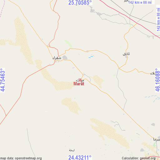
Marāt GPS coordinates[2]
25° 4' 14.304" North, 45° 27' 27.9" East
| Map corner | latitude | longitude |
|---|---|---|
| Upper-left | 25.70585°, | 44.75463° |
| Center: | 25.07064°, | 45.45775° |
| Lower-right: | 24.43211°, | 46.16088° |
| Map W x H: | 141.6×141.6 km | = 88×88mi |
| max Lat: | 31.67252° ⇑56.7% North |
| Marāt: | 25.07064° |
| min Lat: | ⇓43.3% South 16.57946° |
| min Long | Marāt | max Long |
| 35.69014° | 45.45775° | 54.09599° |
| W 61.9%⇐ | ⇒38.1% E |
Elevation
Elevation of Marāt is 692 m = 2270 ft, and this is 170.6 m = 560 ft above average elevation for this country.
| Max E: |
2385 m = 7825 ft | 26.8% |
| Marāt | 692 m 2270 ft | |
| Avg. | 521.4 m = 1711 ft | |
Min E: |
3 m = 10 ft | 73.2% |
See also: Saudi Arabia elevation on elevation.city.
Geographical zone
Marāt is located in North temperate zone (between Tropic of Cancer and the Arctic Circle). Distance of this Northern Tropic circle is 181.7 km =112.9 mi to South.| Distance of | km | miles | from Marāt |
|---|---|---|---|
| North Pole | 7219.5 | 4486 | to North |
| Arctic Circle | 4613.6 | 2866.8 | to North |
| Tropic Cancer | 181.7 | 112.9 | to South |
| Equator | 2787.6 | 1732.1 | to South |


Nearby cities:
15 places around Marāt: (largest is in red/bold)
• Ad Dawādimī
124.4 km =77.3 mi,  239°
239°
• Ad Dilam
210 km =130.5 mi,  124°
124°
• Ain AlBaraha
173.3 km =107.7 mi,  258°
258°
• Al Arţāwīyah
159.7 km =99.2 mi,  356°
356°
• Al Kharj
215.3 km =133.8 mi, 118°
• Al Majma‘ah
94 km =58.4 mi,  353°
353°
• Al Mithnab
151.9 km =94.4 mi,  305°
305°
• Ar Rass
215.9 km =134.2 mi,  294°
294°
• Az Zulfī
151 km =93.8 mi,  334°
334°
• Buraydah
203.8 km =126.6 mi, 313°
• Riyadh
134.4 km =83.5 mi,  108°
108°
• Sājir
87.3 km =54.2 mi,  278°
278°
• Tumayr
81.6 km =50.7 mi,  30°
30°
• Unaizah
187.7 km =116.6 mi, 307°
• shokhaibٍ
104.2 km =64.7 mi,  128°
128°
Sources, notices
• [Note1] Compared only with cities in Saudi Arabia existing in our database
• [Src1] Map data: © OpenStreetMap contributors (CC-BY-SA)
• [Src2] Other city data from geonames.org with taken over terms of usage.
• [Src3] Geographical zone / Annual Mean Temperature by Robert A. Rohde @ Wikipedia
