Qaisumah geodata
Qaisumah (Eastern Province) is a populated place; located in Saudi Arabia in Asia/Riyadh (GMT+3) time zone. With population of 20,685 people, there are 58 cities with bigger population in this country. Compared to other cities in Saudi Arabia, 90.7% of cities are located further ↓South; 66% of cities are located further ←West and 50.5% of cities have higher elevation than Qaisumah. Note1


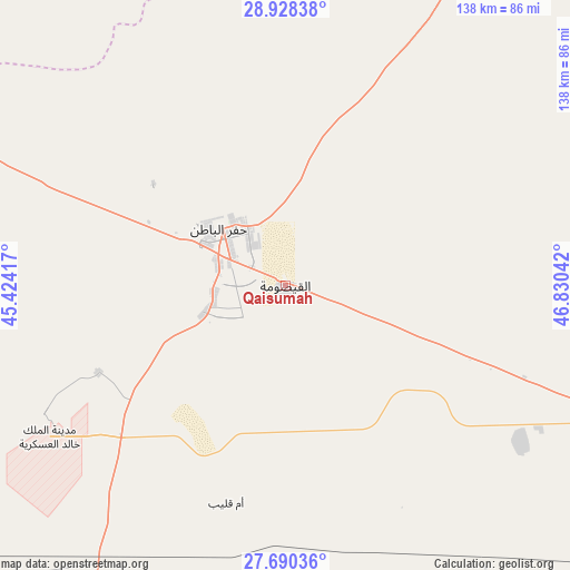
Qaisumah GPS coordinates[2]
28° 18' 40.212" North, 46° 7' 38.244" East
| Map corner | latitude | longitude |
|---|---|---|
| Upper-left | 28.92838°, | 45.42417° |
| Center: | 28.31117°, | 46.12729° |
| Lower-right: | 27.69036°, | 46.83042° |
| Map W x H: | 137.7×137.7 km | = 85.6×85.6mi |
| max Lat: | 31.67252° ⇑9.3% North |
| Qaisumah: | 28.31117° |
| min Lat: | ⇓90.7% South 16.57946° |
| min Long | Qaisumah | max Long |
| 35.69014° | 46.12729° | 54.09599° |
| W 66%⇐ | ⇒34% E |
Elevation
Elevation of Qaisumah is 363 m = 1191 ft, and this is 158.4 m = 520 ft below average elevation for this country.
| Max E: |
2385 m = 7825 ft | 50.5% |
| Avg. | 521.4 m = 1711 ft | |
| Qaisumah | 363 m = 1191 ft | |
Min E: |
3 m = 10 ft | 49.5% |
See also: Saudi Arabia elevation on elevation.city.
Geographical zone
Qaisumah is located in North temperate zone (between Tropic of Cancer and the Arctic Circle). Distance of this Northern Tropic circle is 542 km =336.8 mi to South.| Distance of | km | miles | from Qaisumah |
|---|---|---|---|
| North Pole | 6859.2 | 4262.1 | to North |
| Arctic Circle | 4253.3 | 2642.9 | to North |
| Tropic Cancer | 542 | 336.8 | to South |
| Equator | 3147.9 | 1956 | to South |


Nearby cities:
15 places around Qaisumah: (largest is in red/bold)
• Al Arţāwīyah
215.2 km =133.7 mi,  200°
200°
• Al Bukayrīyah
343.4 km =213.4 mi,  225°
225°
• Al Fuwayliq
351.7 km =218.5 mi, 233°
• Al Khafjī
231.7 km =144 mi,  86°
86°
• Al Majma‘ah
277.6 km =172.5 mi, 195°
• Al Mithnab
331.4 km =205.9 mi,  214°
214°
• As Saffānīyah
258 km =160.3 mi,  98°
98°
• Az Zulfī
258.5 km =160.6 mi, 210°
• Buraydah
306.5 km =190.5 mi,  223°
223°
• Hafar Al-Batin
20.4 km =12.7 mi,  311°
311°
• Marāt
366.4 km =227.7 mi,  190°
190°
• Mulayjah
253.8 km =157.7 mi,  117°
117°
• Tanūmah
238 km =147.9 mi,  235°
235°
• Tumayr
291.1 km =180.9 mi, 185°
• Unaizah
326.9 km =203.1 mi, 220°
Sources, notices
• [Note1] Compared only with cities in Saudi Arabia existing in our database
• [Src1] Map data: © OpenStreetMap contributors (CC-BY-SA)
• [Src2] Other city data from geonames.org with taken over terms of usage.
• [Src3] Geographical zone / Annual Mean Temperature by Robert A. Rohde @ Wikipedia
