Landskrona geodata
Landskrona (Skåne) is a seat of a second-order administrative division; located in Sweden in Europe/Stockholm (GMT+2) time zone. With population of 32,229 people, there are 49 cities with bigger population in this country. Compared to other cities in Sweden, 94.3% of cities are located further ↑North; 83.9% of cities are located further →East and 92.6% of cities have higher elevation than Landskrona. Note1


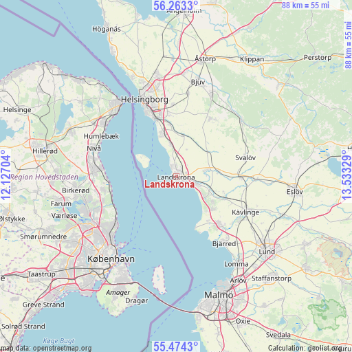
Landskrona GPS coordinates[2]
55° 52' 14.88" North, 12° 49' 48.576" East
| Map corner | latitude | longitude |
|---|---|---|
| Upper-left | 56.2633°, | 12.12704° |
| Center: | 55.8708°, | 12.83016° |
| Lower-right: | 55.4743°, | 13.53329° |
| Map W x H: | 87.7×87.7 km | = 54.5×54.5mi |
| max Lat: | 67.85572° ⇑94.3% North |
| Landskrona: | 55.8708° |
| min Lat: | ⇓5.7% South 55.34337° |
| min Long | Landskrona | max Long |
| 11.1712° | 12.83016° | 24.13676° |
| W 16.1%⇐ | ⇒83.9% E |
Elevation
Elevation of Landskrona is 7 m = 23 ft, and this is 75.6 m = 248 ft below average elevation for this country.
| Max E: |
663 m = 2175 ft | 92.6% |
| Avg. | 82.6 m = 271 ft | |
| Landskrona | 7 m = 23 ft | |
Min E: |
-1 m = -3 ft | 7.4% |
See also: Sweden elevation on elevation.city.
Geographical zone
Landskrona is located in North temperate zone (between Tropic of Cancer and the Arctic Circle). Distance of this North polar circle is 1188.9 km =738.7 mi to North.| Distance of | km | miles | from Landskrona |
|---|---|---|---|
| North Pole | 3794.8 | 2358 | to North |
| Arctic Circle | 1188.9 | 738.7 | to North |
| Tropic Cancer | 3606.3 | 2240.9 | to South |
| Equator | 6212.3 | 3860.1 | to South |


Nearby cities:
15 places around Landskrona: (largest is in red/bold)
• Asmundtorp
6.6 km =4.1 mi,  77°
77°
• Barsebäck
13.8 km =8.6 mi,  147°
147°
• Billeberga
10.7 km =6.6 mi, 82°
• Bårslöv
15.5 km =9.6 mi,  354°
354°
• Dösjebro
13.6 km =8.5 mi,  114°
114°
• Gantofta
13 km =8.1 mi, 353°
• Glumslöv
7.9 km =4.9 mi, 350°
• Hofterup
11.9 km =7.4 mi,  128°
128°
• Häljarp
5.9 km =3.7 mi, 113°
• Löddeköpinge
16.4 km =10.2 mi, 134°
• Rydebäck
11.4 km =7.1 mi,  339°
339°
• Sandskogen
15.8 km =9.8 mi,  142°
142°
• Saxtorpsskogen
8.3 km =5.2 mi,  121°
121°
• Teckomatorp
15.8 km =9.8 mi,  91°
91°
• Vallåkra
10.2 km =6.3 mi,  9°
9°
Sources, notices
• [Note1] Compared only with cities in Sweden existing in our database
• [Src1] Map data: © OpenStreetMap contributors (CC-BY-SA)
• [Src2] Other city data from geonames.org with taken over terms of usage.
• [Src3] Geographical zone / Annual Mean Temperature by Robert A. Rohde @ Wikipedia
