Billeberga geodata
Billeberga (Skåne) is a populated place; located in Sweden in Europe/Stockholm (GMT+2) time zone. With population of 1,050 people, there are 789 cities with bigger population in this country. Compared to other cities in Sweden, 94.1% of cities are located further ↑North; 80.1% of cities are located further →East and 65.3% of cities have higher elevation than Billeberga. Note1


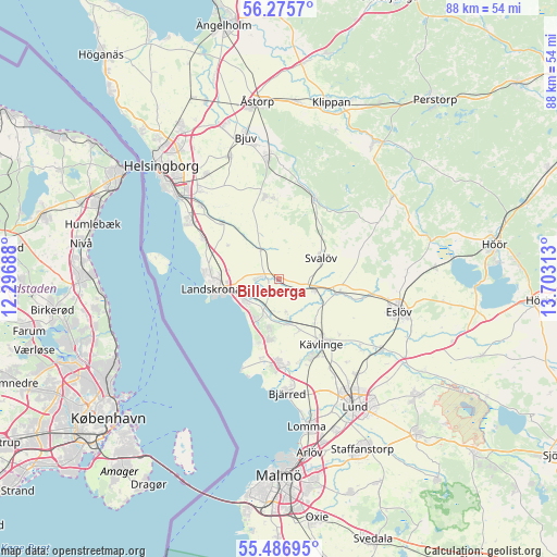
Billeberga GPS coordinates[2]
55° 52' 59.988" North, 13° 0' 0" East
| Map corner | latitude | longitude |
|---|---|---|
| Upper-left | 56.2757°, | 12.29688° |
| Center: | 55.88333°, | 13° |
| Lower-right: | 55.48695°, | 13.70313° |
| Map W x H: | 87.7×87.7 km | = 54.5×54.5mi |
| max Lat: | 67.85572° ⇑94.1% North |
| Billeberga: | 55.88333° |
| min Lat: | ⇓5.9% South 55.34337° |
| min Long | Billeberga | max Long |
| 11.1712° | 13° | 24.13676° |
| W 19.9%⇐ | ⇒80.1% E |
Elevation
Elevation of Billeberga is 30 m = 98 ft, and this is 52.6 m = 173 ft below average elevation for this country.
| Max E: |
663 m = 2175 ft | 65.3% |
| Avg. | 82.6 m = 271 ft | |
| Billeberga | 30 m = 98 ft | |
Min E: |
-1 m = -3 ft | 34.7% |
See also: Sweden elevation on elevation.city.
Geographical zone
Billeberga is located in North temperate zone (between Tropic of Cancer and the Arctic Circle). Distance of this North polar circle is 1187.5 km =737.9 mi to North.| Distance of | km | miles | from Billeberga |
|---|---|---|---|
| North Pole | 3793.4 | 2357.1 | to North |
| Arctic Circle | 1187.5 | 737.9 | to North |
| Tropic Cancer | 3607.7 | 2241.7 | to South |
| Equator | 6213.6 | 3861 | to South |


Nearby cities:
15 places around Billeberga: (largest is in red/bold)
• Asmundtorp
4.2 km =2.6 mi,  270°
270°
• Barsebäck
13.3 km =8.3 mi,  193°
193°
• Dösjebro
7.2 km =4.5 mi,  165°
165°
• Ekeby
13.1 km =8.1 mi,  350°
350°
• Furulund
13.4 km =8.3 mi,  155°
155°
• Hofterup
8.8 km =5.5 mi, 188°
• Häljarp
6.4 km =4 mi,  234°
234°
• Kävlinge
12.3 km =7.6 mi,  145°
145°
• Landskrona
10.7 km =6.6 mi,  262°
262°
• Löddeköpinge
13 km =8.1 mi,  175°
175°
• Marieholm
9.5 km =5.9 mi,  101°
101°
• Saxtorpsskogen
6.7 km =4.2 mi,  211°
211°
• Svalöv
7.5 km =4.7 mi,  63°
63°
• Teckomatorp
5.5 km =3.4 mi,  109°
109°
• Vallåkra
12.5 km =7.8 mi,  314°
314°
Sources, notices
• [Note1] Compared only with cities in Sweden existing in our database
• [Src1] Map data: © OpenStreetMap contributors (CC-BY-SA)
• [Src2] Other city data from geonames.org with taken over terms of usage.
• [Src3] Geographical zone / Annual Mean Temperature by Robert A. Rohde @ Wikipedia
