Ljung geodata
Ljung (Västra Götaland) is a populated place; located in Sweden in Europe/Stockholm (GMT+2) time zone. With population of 727 people, there are 1036 cities with bigger population in this country. Compared to other cities in Sweden, 60.7% of cities are located further ↑North; 78.6% of cities are located further →East and 85.8% of cities have lower elevation than Ljung. Note1
Administrative division(s):
- Level 1: Västra Götaland
- Level 2: Herrljunga Kommun
- Level 3: Grude
- Level 4: Grude socken


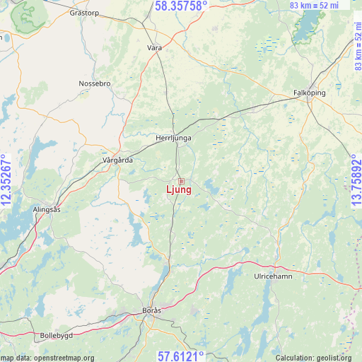
Ljung GPS coordinates[2]
57° 59' 12.408" North, 13° 3' 20.844" East
| Map corner | latitude | longitude |
|---|---|---|
| Upper-left | 58.35758°, | 12.35267° |
| Center: | 57.98678°, | 13.05579° |
| Lower-right: | 57.6121°, | 13.75892° |
| Map W x H: | 82.9×82.9 km | = 51.5×51.5mi |
| max Lat: | 67.85572° ⇑60.7% North |
| Ljung: | 57.98678° |
| min Lat: | ⇓39.3% South 55.34337° |
| min Long | Ljung | max Long |
| 11.1712° | 13.05579° | 24.13676° |
| W 21.4%⇐ | ⇒78.6% E |
Elevation
Elevation of Ljung is 172 m = 564 ft, and this is 89.4 m = 293 ft above average elevation for this country.
| Max E: |
663 m = 2175 ft | 14.2% |
| Ljung | 172 m 564 ft | |
| Avg. | 82.6 m = 271 ft | |
Min E: |
-1 m = -3 ft | 85.8% |
See also: Sweden elevation on elevation.city.
Geographical zone
Ljung is located in North temperate zone (between Tropic of Cancer and the Arctic Circle). Distance of this North polar circle is 953.6 km =592.5 mi to North.| Distance of | km | miles | from Ljung |
|---|---|---|---|
| North Pole | 3559.5 | 2211.8 | to North |
| Arctic Circle | 953.6 | 592.5 | to North |
| Tropic Cancer | 3841.6 | 2387.1 | to South |
| Equator | 6447.5 | 4006.3 | to South |


Nearby cities:
15 places around Ljung: (largest is in red/bold)
• Annelund
1.1 km =0.7 mi,  80°
80°
• Blidsberg
25.9 km =16.1 mi,  103°
103°
• Dalum
26 km =16.2 mi,  112°
112°
• Floby
23.1 km =14.4 mi,  45°
45°
• Fristad
18.2 km =11.3 mi,  188°
188°
• Frufällan
23.2 km =14.4 mi, 193°
• Herrljunga
10.2 km =6.3 mi,  350°
350°
• Hökerum
21.1 km =13.1 mi,  140°
140°
• Jonstorp
20 km =12.4 mi,  274°
274°
• Kinnarp
29.2 km =18.1 mi,  69°
69°
• Sandhem
25.4 km =15.8 mi, 82°
• Sandhult
28.3 km =17.6 mi,  210°
210°
• Timmele
26.2 km =16.3 mi,  122°
122°
• Vedum
20.5 km =12.7 mi, 347°
• Vårgårda
15.6 km =9.7 mi,  291°
291°
Sources, notices
• [Note1] Compared only with cities in Sweden existing in our database
• [Src1] Map data: © OpenStreetMap contributors (CC-BY-SA)
• [Src2] Other city data from geonames.org with taken over terms of usage.
• [Src3] Geographical zone / Annual Mean Temperature by Robert A. Rohde @ Wikipedia
