Hökerum geodata
Hökerum (Västra Götaland) is a populated place; located in Sweden in Europe/Stockholm (GMT+2) time zone. With population of 642 people, there are 1131 cities with bigger population in this country. Compared to other cities in Sweden, 63.2% of cities are located further ↑North; 74.3% of cities are located further →East and 89.3% of cities have lower elevation than Hökerum. Note1


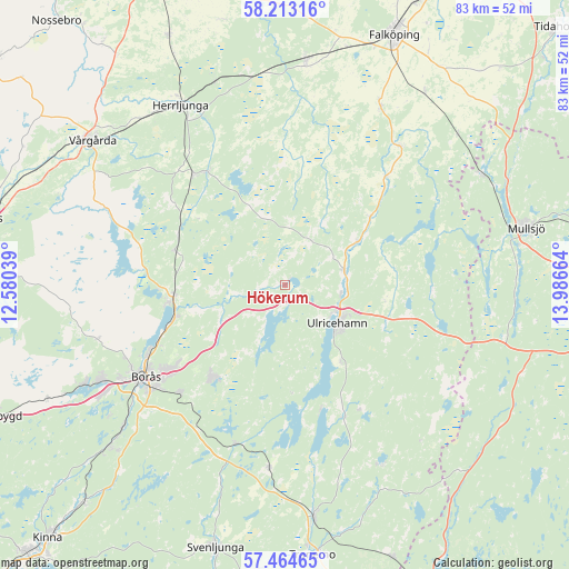
Hökerum GPS coordinates[2]
57° 50' 27.06" North, 13° 17' 0.636" East
| Map corner | latitude | longitude |
|---|---|---|
| Upper-left | 58.21316°, | 12.58039° |
| Center: | 57.84085°, | 13.28351° |
| Lower-right: | 57.46465°, | 13.98664° |
| Map W x H: | 83.2×83.2 km | = 51.7×51.7mi |
| max Lat: | 67.85572° ⇑63.2% North |
| Hökerum: | 57.84085° |
| min Lat: | ⇓36.8% South 55.34337° |
| min Long | Hökerum | max Long |
| 11.1712° | 13.28351° | 24.13676° |
| W 25.7%⇐ | ⇒74.3% E |
Elevation
Elevation of Hökerum is 194 m = 636 ft, and this is 111.4 m = 365 ft above average elevation for this country.
| Max E: |
663 m = 2175 ft | 10.7% |
| Hökerum | 194 m 636 ft | |
| Avg. | 82.6 m = 271 ft | |
Min E: |
-1 m = -3 ft | 89.3% |
See also: Sweden elevation on elevation.city.
Geographical zone
Hökerum is located in North temperate zone (between Tropic of Cancer and the Arctic Circle). Distance of this North polar circle is 969.9 km =602.7 mi to North.| Distance of | km | miles | from Hökerum |
|---|---|---|---|
| North Pole | 3575.8 | 2221.9 | to North |
| Arctic Circle | 969.9 | 602.7 | to North |
| Tropic Cancer | 3825.4 | 2377 | to South |
| Equator | 6431.3 | 3996.2 | to South |


Nearby cities:
15 places around Hökerum: (largest is in red/bold)
• Annelund
20.5 km =12.7 mi,  323°
323°
• Blidsberg
15.7 km =9.8 mi,  48°
48°
• Borås
24.3 km =15.1 mi,  236°
236°
• Dalsjöfors
18.2 km =11.3 mi,  220°
220°
• Dalum
12.5 km =7.8 mi,  59°
59°
• Fristad
16.3 km =10.1 mi,  263°
263°
• Frufällan
19.8 km =12.3 mi,  251°
251°
• Gällstad
21.3 km =13.2 mi,  155°
155°
• Gånghester
22.3 km =13.9 mi,  225°
225°
• Ljung
21.1 km =13.1 mi, 320°
• Målsryd
22.3 km =13.9 mi, 218°
• Sandhem
22.8 km =14.2 mi,  31°
31°
• Timmele
8.8 km =5.5 mi,  76°
76°
• Ulricehamn
9.5 km =5.9 mi,  125°
125°
• Vegby
18.5 km =11.5 mi, 161°
Sources, notices
• [Note1] Compared only with cities in Sweden existing in our database
• [Src1] Map data: © OpenStreetMap contributors (CC-BY-SA)
• [Src2] Other city data from geonames.org with taken over terms of usage.
• [Src3] Geographical zone / Annual Mean Temperature by Robert A. Rohde @ Wikipedia
