Tanumshede geodata
Tanumshede (Västra Götaland) is a seat of a second-order administrative division; located in Sweden in Europe/Stockholm (GMT+2) time zone. With population of 1,774 people, there are 575 cities with bigger population in this country. Compared to other cities in Sweden, 50.9% of cities are located further ↓South; 99.3% of cities are located further →East and 52.7% of cities have lower elevation than Tanumshede. Note1


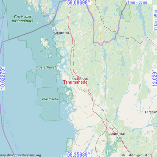
Tanumshede GPS coordinates[2]
58° 43' 25.86" North, 11° 19' 33.132" East
| Map corner | latitude | longitude |
|---|---|---|
| Upper-left | 59.08698°, | 10.62275° |
| Center: | 58.72385°, | 11.32587° |
| Lower-right: | 58.35689°, | 12.029° |
| Map W x H: | 81.2×81.2 km | = 50.5×50.5mi |
| max Lat: | 67.85572° ⇑49.1% North |
| Tanumshede: | 58.72385° |
| min Lat: | ⇓50.9% South 55.34337° |
| min Long | Tanumshede | max Long |
| 11.1712° | 11.32587° | 24.13676° |
| W 0.7%⇐ | ⇒99.3% E |
Elevation
Elevation of Tanumshede is 55 m = 180 ft, and this is 27.6 m = 91 ft below average elevation for this country.
| Max E: |
663 m = 2175 ft | 47.3% |
| Avg. | 82.6 m = 271 ft | |
| Tanumshede | 55 m = 180 ft | |
Min E: |
-1 m = -3 ft | 52.7% |
See also: Sweden elevation on elevation.city.
Geographical zone
Tanumshede is located in North temperate zone (between Tropic of Cancer and the Arctic Circle). Distance of this North polar circle is 871.7 km =541.6 mi to North.| Distance of | km | miles | from Tanumshede |
|---|---|---|---|
| North Pole | 3477.6 | 2160.9 | to North |
| Arctic Circle | 871.7 | 541.6 | to North |
| Tropic Cancer | 3923.6 | 2438 | to South |
| Equator | 6529.5 | 4057.2 | to South |


Nearby cities:
15 places around Tanumshede: (largest is in red/bold)
• Brastad
38.9 km =24.2 mi,  166°
166°
• Dingle
26.3 km =16.3 mi,  146°
146°
• Ed
40.8 km =25.4 mi,  59°
59°
• Fjällbacka
14 km =8.7 mi,  190°
190°
• Grebbestad
4.6 km =2.9 mi,  239°
239°
• Hamburgsund
19.3 km =12 mi, 189°
• Hunnebostrand
31.4 km =19.5 mi,  182°
182°
• Hällevadsholm
20.3 km =12.6 mi,  142°
142°
• Kungshamn
40.3 km =25 mi, 185°
• Munkedal
35 km =21.7 mi, 144°
• Skee
22.7 km =14.1 mi,  351°
351°
• Smögen
41.3 km =25.7 mi, 188°
• Strömstad
25.6 km =15.9 mi,  339°
339°
• Väjern
38 km =23.6 mi, 185°
• Ödsmål
9.1 km =5.7 mi,  95°
95°
In other languages:
- In Spanish: Grabados rupestres de Tanum
- In France: Gravures rupestres de Tanum
- In Italian: Tanum
- In Russian: Наскальные рельефы в Тануме
- In Chinese: 塔努姆斯海德
Sources, notices
• [Note1] Compared only with cities in Sweden existing in our database
• [Src1] Map data: © OpenStreetMap contributors (CC-BY-SA)
• [Src2] Other city data from geonames.org with taken over terms of usage.
• [Src3] Geographical zone / Annual Mean Temperature by Robert A. Rohde @ Wikipedia
