Hällevadsholm geodata
Hällevadsholm (Västra Götaland) is a populated place; located in Sweden in Europe/Stockholm (GMT+2) time zone. With population of 816 people, there are 950 cities with bigger population in this country. Compared to other cities in Sweden, 51.1% of cities are located further ↑North; 98.8% of cities are located further →East and 67.4% of cities have lower elevation than Hällevadsholm. Note1
Administrative division(s):
- Level 1: Västra Götaland
- Level 2: Munkedals Kommun
- Level 3: Svarteborg
- Level 4: Svarteborg socken


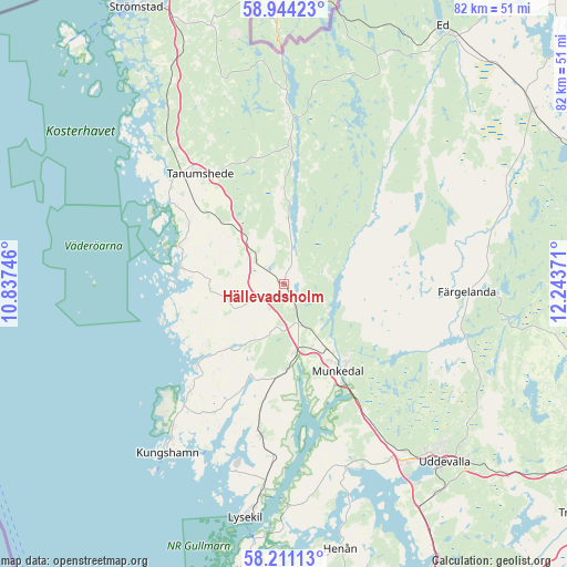
Hällevadsholm GPS coordinates[2]
58° 34' 46.56" North, 11° 32' 26.088" East
| Map corner | latitude | longitude |
|---|---|---|
| Upper-left | 58.94423°, | 10.83746° |
| Center: | 58.5796°, | 11.54058° |
| Lower-right: | 58.21113°, | 12.24371° |
| Map W x H: | 81.5×81.5 km | = 50.6×50.6mi |
| max Lat: | 67.85572° ⇑51.1% North |
| Hällevadsholm: | 58.5796° |
| min Lat: | ⇓48.9% South 55.34337° |
| min Long | Hällevadsholm | max Long |
| 11.1712° | 11.54058° | 24.13676° |
| W 1.2%⇐ | ⇒98.8% E |
Elevation
Elevation of Hällevadsholm is 91 m = 299 ft, and this is 8.4 m = 28 ft above average elevation for this country.
| Max E: |
663 m = 2175 ft | 32.6% |
| Hällevadsholm | 91 m 299 ft | |
| Avg. | 82.6 m = 271 ft | |
Min E: |
-1 m = -3 ft | 67.4% |
See also: Sweden elevation on elevation.city.
Geographical zone
Hällevadsholm is located in North temperate zone (between Tropic of Cancer and the Arctic Circle). Distance of this North polar circle is 887.7 km =551.6 mi to North.| Distance of | km | miles | from Hällevadsholm |
|---|---|---|---|
| North Pole | 3493.6 | 2170.8 | to North |
| Arctic Circle | 887.7 | 551.6 | to North |
| Tropic Cancer | 3907.5 | 2428 | to South |
| Equator | 6513.4 | 4047.2 | to South |


Nearby cities:
15 places around Hällevadsholm: (largest is in red/bold)
• Brastad
22.1 km =13.7 mi,  188°
188°
• Dingle
6.2 km =3.9 mi,  159°
159°
• Fjällbacka
15.1 km =9.4 mi,  278°
278°
• Färgelanda
26.2 km =16.3 mi,  92°
92°
• Grebbestad
21.3 km =13.2 mi,  309°
309°
• Hamburgsund
15.8 km =9.8 mi,  259°
259°
• Hunnebostrand
20.7 km =12.9 mi,  221°
221°
• Kungshamn
29.1 km =18.1 mi,  214°
214°
• Munkedal
14.8 km =9.2 mi,  148°
148°
• Smögen
30.9 km =19.2 mi, 216°
• Sunningen
32.2 km =20 mi, 148°
• Tanumshede
20.3 km =12.6 mi,  322°
322°
• Väjern
27 km =16.8 mi, 216°
• Ödeborg
25.5 km =15.8 mi,  98°
98°
• Ödsmål
15.6 km =9.7 mi,  347°
347°
Sources, notices
• [Note1] Compared only with cities in Sweden existing in our database
• [Src1] Map data: © OpenStreetMap contributors (CC-BY-SA)
• [Src2] Other city data from geonames.org with taken over terms of usage.
• [Src3] Geographical zone / Annual Mean Temperature by Robert A. Rohde @ Wikipedia
