Strömstad geodata
Strömstad (Västra Götaland) is a seat of a second-order administrative division; located in Sweden in Europe/Stockholm (GMT+2) time zone. With population of 7,176 people, there are 204 cities with bigger population in this country. Compared to other cities in Sweden, 52.7% of cities are located further ↓South; 100% of cities are located further →East and 95.4% of cities have higher elevation than Strömstad. Note1


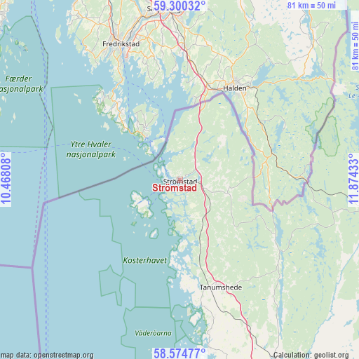
Strömstad GPS coordinates[2]
58° 56' 22.02" North, 11° 10' 16.32" East
| Map corner | latitude | longitude |
|---|---|---|
| Upper-left | 59.30032°, | 10.46808° |
| Center: | 58.93945°, | 11.1712° |
| Lower-right: | 58.57477°, | 11.87433° |
| Map W x H: | 80.7×80.7 km | = 50.1×50.1mi |
| max Lat: | 67.85572° ⇑47.3% North |
| Strömstad: | 58.93945° |
| min Lat: | ⇓52.7% South 55.34337° |
| min Long | Strömstad | max Long |
| 11.1712° | 11.1712° | 24.13676° |
| W 0%⇐ | ⇒100% E |
Elevation
Elevation of Strömstad is 5 m = 16 ft, and this is 77.6 m = 255 ft below average elevation for this country.
| Max E: |
663 m = 2175 ft | 95.4% |
| Avg. | 82.6 m = 271 ft | |
| Strömstad | 5 m = 16 ft | |
Min E: |
-1 m = -3 ft | 4.6% |
See also: Sweden elevation on elevation.city.
Geographical zone
Strömstad is located in North temperate zone (between Tropic of Cancer and the Arctic Circle). Distance of this North polar circle is 847.7 km =526.7 mi to North.| Distance of | km | miles | from Strömstad |
|---|---|---|---|
| North Pole | 3453.6 | 2146 | to North |
| Arctic Circle | 847.7 | 526.7 | to North |
| Tropic Cancer | 3947.5 | 2452.9 | to South |
| Equator | 6553.5 | 4072.2 | to South |


Nearby cities:
15 places around Strömstad: (largest is in red/bold)
• Bengtsfors
61.6 km =38.3 mi,  80°
80°
• Billingsfors
62 km =38.5 mi,  85°
85°
• Bäckefors
58.9 km =36.6 mi,  104°
104°
• Dingle
51.5 km =32 mi,  152°
152°
• Ed
43.8 km =27.2 mi, 93°
• Fjällbacka
38.3 km =23.8 mi,  170°
170°
• Grebbestad
26.8 km =16.7 mi, 169°
• Hamburgsund
43.4 km =27 mi, 172°
• Hunnebostrand
55.9 km =34.7 mi, 172°
• Hällevadsholm
45.3 km =28.1 mi, 151°
• Munkedal
60.1 km =37.3 mi, 151°
• Skee
5.8 km =3.6 mi,  105°
105°
• Tanumshede
25.6 km =15.9 mi,  159°
159°
• Väjern
62.1 km =38.6 mi, 174°
• Ödsmål
30.6 km =19 mi,  144°
144°
Sources, notices
• [Note1] Compared only with cities in Sweden existing in our database
• [Src1] Map data: © OpenStreetMap contributors (CC-BY-SA)
• [Src2] Other city data from geonames.org with taken over terms of usage.
• [Src3] Geographical zone / Annual Mean Temperature by Robert A. Rohde @ Wikipedia
