Svanberga geodata
Svanberga (Stockholm) is a populated place; located in Sweden in Europe/Stockholm (GMT+2) time zone. With population of 524 people, there are 1283 cities with bigger population in this country. Compared to other cities in Sweden, 71.6% of cities are located further ↓South; 91.7% of cities are located further ←West and 70.9% of cities have higher elevation than Svanberga. Note1


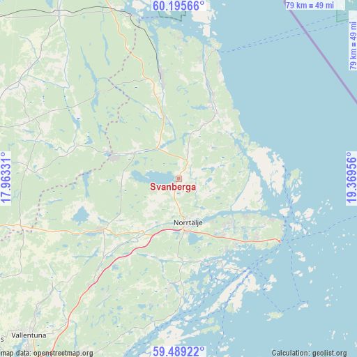
Svanberga GPS coordinates[2]
59° 50' 39.516" North, 18° 39' 59.148" East
| Map corner | latitude | longitude |
|---|---|---|
| Upper-left | 60.19566°, | 17.96331° |
| Center: | 59.84431°, | 18.66643° |
| Lower-right: | 59.48922°, | 19.36956° |
| Map W x H: | 78.5×78.5 km | = 48.8×48.8mi |
| max Lat: | 67.85572° ⇑28.4% North |
| Svanberga: | 59.84431° |
| min Lat: | ⇓71.6% South 55.34337° |
| min Long | Svanberga | max Long |
| 11.1712° | 18.66643° | 24.13676° |
| W 91.7%⇐ | ⇒8.3% E |
Elevation
Elevation of Svanberga is 24 m = 79 ft, and this is 58.6 m = 192 ft below average elevation for this country.
| Max E: |
663 m = 2175 ft | 70.9% |
| Avg. | 82.6 m = 271 ft | |
| Svanberga | 24 m = 79 ft | |
Min E: |
-1 m = -3 ft | 29.1% |
See also: Sweden elevation on elevation.city.
Geographical zone
Svanberga is located in North temperate zone (between Tropic of Cancer and the Arctic Circle). Distance of this North polar circle is 747.1 km =464.2 mi to North.| Distance of | km | miles | from Svanberga |
|---|---|---|---|
| North Pole | 3353 | 2083.5 | to North |
| Arctic Circle | 747.1 | 464.2 | to North |
| Tropic Cancer | 4048.1 | 2515.4 | to South |
| Equator | 6654.1 | 4134.7 | to South |


Nearby cities:
15 places around Svanberga: (largest is in red/bold)
• Almunge
34.7 km =21.6 mi,  277°
277°
• Arnö
30.3 km =18.8 mi,  356°
356°
• Bergshamra
23.4 km =14.5 mi,  185°
185°
• Edsbro
11.2 km =7 mi,  299°
299°
• Gräddö
22.3 km =13.9 mi,  112°
112°
• Hallstavik
23.2 km =14.4 mi,  350°
350°
• Knutby
23.5 km =14.6 mi,  287°
287°
• Kårsta
30.4 km =18.9 mi,  226°
226°
• Norrtälje
9.8 km =6.1 mi,  167°
167°
• Nykvarn
21.1 km =13.1 mi,  256°
256°
• Rimbo
19.8 km =12.3 mi,  237°
237°
• Rörvik
14.4 km =8.9 mi,  64°
64°
• Skänninge
14.2 km =8.8 mi,  314°
314°
• Strömma
24 km =14.9 mi,  129°
129°
• Älmsta
15.5 km =9.6 mi,  28°
28°
Sources, notices
• [Note1] Compared only with cities in Sweden existing in our database
• [Src1] Map data: © OpenStreetMap contributors (CC-BY-SA)
• [Src2] Other city data from geonames.org with taken over terms of usage.
• [Src3] Geographical zone / Annual Mean Temperature by Robert A. Rohde @ Wikipedia
