Rörvik geodata
Rörvik (Stockholm) is a populated place; located in Sweden in Europe/Stockholm (GMT+2) time zone. With population of 555 people, there are 1226 cities with bigger population in this country. Compared to other cities in Sweden, 72.4% of cities are located further ↓South; 92.7% of cities are located further ←West and 75.3% of cities have higher elevation than Rörvik. Note1


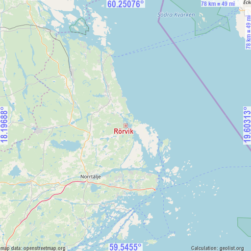
Rörvik GPS coordinates[2]
59° 54' 0" North, 18° 54' 0" East
| Map corner | latitude | longitude |
|---|---|---|
| Upper-left | 60.25076°, | 18.19688° |
| Center: | 59.9°, | 18.9° |
| Lower-right: | 59.5455°, | 19.60313° |
| Map W x H: | 78.4×78.4 km | = 48.7×48.7mi |
| max Lat: | 67.85572° ⇑27.6% North |
| Rörvik: | 59.9° |
| min Lat: | ⇓72.4% South 55.34337° |
| min Long | Rörvik | max Long |
| 11.1712° | 18.9° | 24.13676° |
| W 92.7%⇐ | ⇒7.3% E |
Elevation
Elevation of Rörvik is 20 m = 66 ft, and this is 62.6 m = 205 ft below average elevation for this country.
| Max E: |
663 m = 2175 ft | 75.3% |
| Avg. | 82.6 m = 271 ft | |
| Rörvik | 20 m = 66 ft | |
Min E: |
-1 m = -3 ft | 24.7% |
See also: Sweden elevation on elevation.city.
Geographical zone
Rörvik is located in North temperate zone (between Tropic of Cancer and the Arctic Circle). Distance of this North polar circle is 740.9 km =460.4 mi to North.| Distance of | km | miles | from Rörvik |
|---|---|---|---|
| North Pole | 3346.8 | 2079.6 | to North |
| Arctic Circle | 740.9 | 460.4 | to North |
| Tropic Cancer | 4054.3 | 2519.2 | to South |
| Equator | 6660.3 | 4138.5 | to South |


Nearby cities:
15 places around Rörvik: (largest is in red/bold)
• Arnö
28.3 km =17.6 mi,  328°
328°
• Bergshamra
33.2 km =20.6 mi,  207°
207°
• Edsbro
22.8 km =14.2 mi,  268°
268°
• Gräddö
16.6 km =10.3 mi,  153°
153°
• Hallstavik
23.6 km =14.7 mi,  314°
314°
• Knutby
35.4 km =22 mi, 271°
• Kårsta
44.3 km =27.5 mi,  232°
232°
• Marieberg
43.2 km =26.8 mi, 329°
• Norrtälje
19.2 km =11.9 mi, 214°
• Nykvarn
35.3 km =21.9 mi,  251°
251°
• Rimbo
34.2 km =21.3 mi,  240°
240°
• Skänninge
23.5 km =14.6 mi,  279°
279°
• Strömma
22 km =13.7 mi,  165°
165°
• Svanberga
14.4 km =8.9 mi, 244°
• Älmsta
9.3 km =5.8 mi,  323°
323°
Sources, notices
• [Note1] Compared only with cities in Sweden existing in our database
• [Src1] Map data: © OpenStreetMap contributors (CC-BY-SA)
• [Src2] Other city data from geonames.org with taken over terms of usage.
• [Src3] Geographical zone / Annual Mean Temperature by Robert A. Rohde @ Wikipedia
