Stora Levene geodata
Stora Levene (Västra Götaland) is a populated place; located in Sweden in Europe/Stockholm (GMT+2) time zone. With population of 809 people, there are 959 cities with bigger population in this country. Compared to other cities in Sweden, 56.3% of cities are located further ↑North; 82.1% of cities are located further →East and 65.7% of cities have lower elevation than Stora Levene. Note1


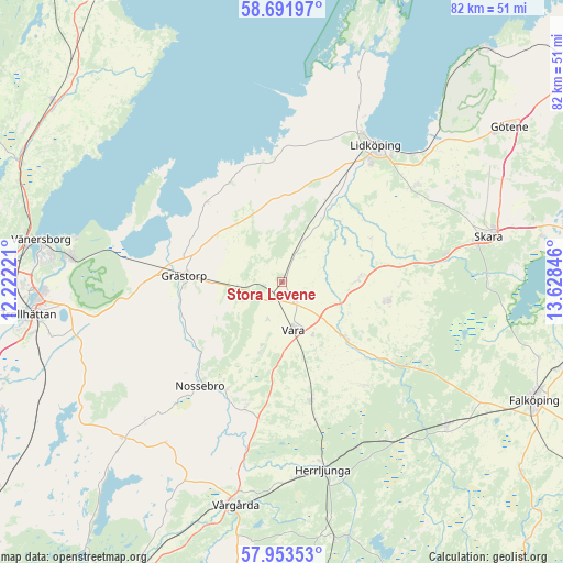
Stora Levene GPS coordinates[2]
58° 19' 28.848" North, 12° 55' 31.188" East
| Map corner | latitude | longitude |
|---|---|---|
| Upper-left | 58.69197°, | 12.22221° |
| Center: | 58.32468°, | 12.92533° |
| Lower-right: | 57.95353°, | 13.62846° |
| Map W x H: | 82.1×82.1 km | = 51×51mi |
| max Lat: | 67.85572° ⇑56.3% North |
| Stora Levene: | 58.32468° |
| min Lat: | ⇓43.7% South 55.34337° |
| min Long | Stora Levene | max Long |
| 11.1712° | 12.92533° | 24.13676° |
| W 17.9%⇐ | ⇒82.1% E |
Elevation
Elevation of Stora Levene is 85 m = 279 ft, and this is 2.4 m = 8 ft above average elevation for this country.
| Max E: |
663 m = 2175 ft | 34.3% |
| Stora Levene | 85 m 279 ft | |
| Avg. | 82.6 m = 271 ft | |
Min E: |
-1 m = -3 ft | 65.7% |
See also: Sweden elevation on elevation.city.
Geographical zone
Stora Levene is located in North temperate zone (between Tropic of Cancer and the Arctic Circle). Distance of this North polar circle is 916.1 km =569.2 mi to North.| Distance of | km | miles | from Stora Levene |
|---|---|---|---|
| North Pole | 3522 | 2188.5 | to North |
| Arctic Circle | 916.1 | 569.2 | to North |
| Tropic Cancer | 3879.2 | 2410.4 | to South |
| Equator | 6485.1 | 4029.7 | to South |


Nearby cities:
15 places around Stora Levene: (largest is in red/bold)
• Ardala
24.3 km =15.1 mi,  80°
80°
• Filsbäck
26.4 km =16.4 mi,  45°
45°
• Floby
32 km =19.9 mi,  131°
131°
• Grästorp
14.3 km =8.9 mi,  273°
273°
• Herrljunga
28.1 km =17.5 mi,  167°
167°
• Järpås
7 km =4.3 mi,  20°
20°
• Kvänum
15.3 km =9.5 mi,  100°
100°
• Källby
30.3 km =18.8 mi, 47°
• Lidköping
24.2 km =15 mi,  33°
33°
• Nossebro
19.5 km =12.1 mi,  218°
218°
• Skara
30.7 km =19.1 mi, 77°
• Vara
7.1 km =4.4 mi, 166°
• Vargön
31.4 km =19.5 mi,  276°
276°
• Vedum
17.9 km =11.1 mi, 169°
• Vinninga
24.3 km =15.1 mi, 54°
Sources, notices
• [Note1] Compared only with cities in Sweden existing in our database
• [Src1] Map data: © OpenStreetMap contributors (CC-BY-SA)
• [Src2] Other city data from geonames.org with taken over terms of usage.
• [Src3] Geographical zone / Annual Mean Temperature by Robert A. Rohde @ Wikipedia
