Grästorp geodata
Grästorp (Västra Götaland) is a seat of a second-order administrative division; located in Sweden in Europe/Stockholm (GMT+2) time zone. With population of 2,946 people, there are 410 cities with bigger population in this country. Compared to other cities in Sweden, 56.2% of cities are located further ↑North; 86.7% of cities are located further →East and 57.5% of cities have lower elevation than Grästorp. Note1


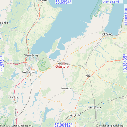
Grästorp GPS coordinates[2]
58° 19' 55.884" North, 12° 40' 52.392" East
| Map corner | latitude | longitude |
|---|---|---|
| Upper-left | 58.6994°, | 11.9781° |
| Center: | 58.33219°, | 12.68122° |
| Lower-right: | 57.96112°, | 13.38435° |
| Map W x H: | 82.1×82.1 km | = 51×51mi |
| max Lat: | 67.85572° ⇑56.2% North |
| Grästorp: | 58.33219° |
| min Lat: | ⇓43.8% South 55.34337° |
| min Long | Grästorp | max Long |
| 11.1712° | 12.68122° | 24.13676° |
| W 13.3%⇐ | ⇒86.7% E |
Elevation
Elevation of Grästorp is 64 m = 210 ft, and this is 18.6 m = 61 ft below average elevation for this country.
| Max E: |
663 m = 2175 ft | 42.5% |
| Avg. | 82.6 m = 271 ft | |
| Grästorp | 64 m = 210 ft | |
Min E: |
-1 m = -3 ft | 57.5% |
See also: Sweden elevation on elevation.city.
Geographical zone
Grästorp is located in North temperate zone (between Tropic of Cancer and the Arctic Circle). Distance of this North polar circle is 915.2 km =568.7 mi to North.| Distance of | km | miles | from Grästorp |
|---|---|---|---|
| North Pole | 3521.1 | 2187.9 | to North |
| Arctic Circle | 915.2 | 568.7 | to North |
| Tropic Cancer | 3880 | 2410.9 | to South |
| Equator | 6485.9 | 4030.2 | to South |


Nearby cities:
15 places around Grästorp: (largest is in red/bold)
• Brålanda
32.2 km =20 mi,  323°
323°
• Frändefors
29.7 km =18.5 mi,  308°
308°
• Järpås
17.6 km =10.9 mi,  71°
71°
• Kvänum
29.5 km =18.3 mi,  96°
96°
• Nossebro
16.2 km =10.1 mi,  172°
172°
• Sjuntorp
30.9 km =19.2 mi,  241°
241°
• Sollebrunn
25.5 km =15.8 mi,  199°
199°
• Stora Levene
14.3 km =8.9 mi,  93°
93°
• Trollhättan
23.6 km =14.7 mi,  256°
256°
• Upphärad
29.3 km =18.2 mi,  228°
228°
• Vara
17.7 km =11 mi,  115°
115°
• Vargön
17.2 km =10.7 mi,  278°
278°
• Vedum
25.5 km =15.8 mi,  136°
136°
• Velanda
24.6 km =15.3 mi, 242°
• Vänersborg
21.6 km =13.4 mi, 284°
Sources, notices
• [Note1] Compared only with cities in Sweden existing in our database
• [Src1] Map data: © OpenStreetMap contributors (CC-BY-SA)
• [Src2] Other city data from geonames.org with taken over terms of usage.
• [Src3] Geographical zone / Annual Mean Temperature by Robert A. Rohde @ Wikipedia
