Vargön geodata
Vargön (Västra Götaland) is a populated place; located in Sweden in Europe/Stockholm (GMT+2) time zone. With population of 4,981 people, there are 275 cities with bigger population in this country. Compared to other cities in Sweden, 55.5% of cities are located further ↑North; 89.4% of cities are located further →East and 54.9% of cities have lower elevation than Vargön. Note1


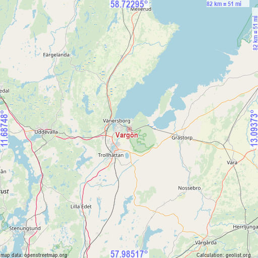
Vargön GPS coordinates[2]
58° 21' 21.564" North, 12° 23' 26.16" East
| Map corner | latitude | longitude |
|---|---|---|
| Upper-left | 58.72295°, | 11.68748° |
| Center: | 58.35599°, | 12.3906° |
| Lower-right: | 57.98517°, | 13.09373° |
| Map W x H: | 82×82 km | = 51×51mi |
| max Lat: | 67.85572° ⇑55.5% North |
| Vargön: | 58.35599° |
| min Lat: | ⇓44.5% South 55.34337° |
| min Long | Vargön | max Long |
| 11.1712° | 12.3906° | 24.13676° |
| W 10.6%⇐ | ⇒89.4% E |
Elevation
Elevation of Vargön is 59 m = 194 ft, and this is 23.6 m = 77 ft below average elevation for this country.
| Max E: |
663 m = 2175 ft | 45.1% |
| Avg. | 82.6 m = 271 ft | |
| Vargön | 59 m = 194 ft | |
Min E: |
-1 m = -3 ft | 54.9% |
See also: Sweden elevation on elevation.city.
Geographical zone
Vargön is located in North temperate zone (between Tropic of Cancer and the Arctic Circle). Distance of this North polar circle is 912.6 km =567.1 mi to North.| Distance of | km | miles | from Vargön |
|---|---|---|---|
| North Pole | 3518.5 | 2186.3 | to North |
| Arctic Circle | 912.6 | 567.1 | to North |
| Tropic Cancer | 3882.7 | 2412.6 | to South |
| Equator | 6488.6 | 4031.8 | to South |


Nearby cities:
15 places around Vargön: (largest is in red/bold)
• Brålanda
23.2 km =14.4 mi,  354°
354°
• Frändefors
17.2 km =10.7 mi,  338°
338°
• Grästorp
17.2 km =10.7 mi,  98°
98°
• Göta
31.1 km =19.3 mi,  206°
206°
• Lilla Edet
29 km =18 mi, 211°
• Ljungskile
31.1 km =19.3 mi,  242°
242°
• Nossebro
26.7 km =16.6 mi,  134°
134°
• Sjuntorp
20.1 km =12.5 mi, 210°
• Sollebrunn
27.9 km =17.3 mi,  162°
162°
• Stora Levene
31.4 km =19.5 mi, 96°
• Trollhättan
10 km =6.2 mi,  216°
216°
• Uddevalla
26.2 km =16.3 mi,  268°
268°
• Upphärad
22.6 km =14 mi,  192°
192°
• Velanda
14.9 km =9.3 mi,  198°
198°
• Vänersborg
4.8 km =3 mi,  305°
305°
Sources, notices
• [Note1] Compared only with cities in Sweden existing in our database
• [Src1] Map data: © OpenStreetMap contributors (CC-BY-SA)
• [Src2] Other city data from geonames.org with taken over terms of usage.
• [Src3] Geographical zone / Annual Mean Temperature by Robert A. Rohde @ Wikipedia
