Vara geodata
Vara (Västra Götaland) is a seat of a second-order administrative division; located in Sweden in Europe/Stockholm (GMT+2) time zone. With population of 4,052 people, there are 317 cities with bigger population in this country. Compared to other cities in Sweden, 57.1% of cities are located further ↑North; 81.2% of cities are located further →East and 65.3% of cities have lower elevation than Vara. Note1


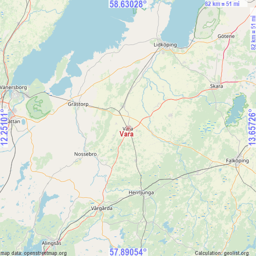
Vara GPS coordinates[2]
58° 15' 44.424" North, 12° 57' 14.868" East
| Map corner | latitude | longitude |
|---|---|---|
| Upper-left | 58.63028°, | 12.25101° |
| Center: | 58.26234°, | 12.95413° |
| Lower-right: | 57.89054°, | 13.65726° |
| Map W x H: | 82.3×82.2 km | = 51.1×51.1mi |
| max Lat: | 67.85572° ⇑57.1% North |
| Vara: | 58.26234° |
| min Lat: | ⇓42.9% South 55.34337° |
| min Long | Vara | max Long |
| 11.1712° | 12.95413° | 24.13676° |
| W 18.8%⇐ | ⇒81.2% E |
Elevation
Elevation of Vara is 84 m = 276 ft, and this is 1.4 m = 5 ft above average elevation for this country.
| Max E: |
663 m = 2175 ft | 34.7% |
| Vara | 84 m 276 ft | |
| Avg. | 82.6 m = 271 ft | |
Min E: |
-1 m = -3 ft | 65.3% |
See also: Sweden elevation on elevation.city.
Geographical zone
Vara is located in North temperate zone (between Tropic of Cancer and the Arctic Circle). Distance of this North polar circle is 923 km =573.5 mi to North.| Distance of | km | miles | from Vara |
|---|---|---|---|
| North Pole | 3528.9 | 2192.8 | to North |
| Arctic Circle | 923 | 573.5 | to North |
| Tropic Cancer | 3872.2 | 2406.1 | to South |
| Equator | 6478.2 | 4025.4 | to South |


Nearby cities:
15 places around Vara: (largest is in red/bold)
• Ardala
24.9 km =15.5 mi,  63°
63°
• Filsbäck
30.7 km =19.1 mi,  33°
33°
• Floby
26.4 km =16.4 mi,  122°
122°
• Grästorp
17.7 km =11 mi,  295°
295°
• Herrljunga
21 km =13 mi,  168°
168°
• Järpås
13.5 km =8.4 mi,  3°
3°
• Kvänum
14 km =8.7 mi,  72°
72°
• Lidköping
29.5 km =18.3 mi,  23°
23°
• Ljung
31.2 km =19.4 mi, 168°
• Nossebro
16.2 km =10.1 mi,  239°
239°
• Sollebrunn
29.5 km =18.3 mi, 236°
• Stora Levene
7.1 km =4.4 mi,  346°
346°
• Vedum
10.8 km =6.7 mi, 170°
• Vinninga
27.7 km =17.2 mi,  41°
41°
• Vårgårda
26.5 km =16.5 mi,  198°
198°
Sources, notices
• [Note1] Compared only with cities in Sweden existing in our database
• [Src1] Map data: © OpenStreetMap contributors (CC-BY-SA)
• [Src2] Other city data from geonames.org with taken over terms of usage.
• [Src3] Geographical zone / Annual Mean Temperature by Robert A. Rohde @ Wikipedia
