Vedum geodata
Vedum (Västra Götaland) is a populated place; located in Sweden in Europe/Stockholm (GMT+2) time zone. With population of 960 people, there are 842 cities with bigger population in this country. Compared to other cities in Sweden, 58.4% of cities are located further ↑North; 80.3% of cities are located further →East and 73.4% of cities have lower elevation than Vedum. Note1


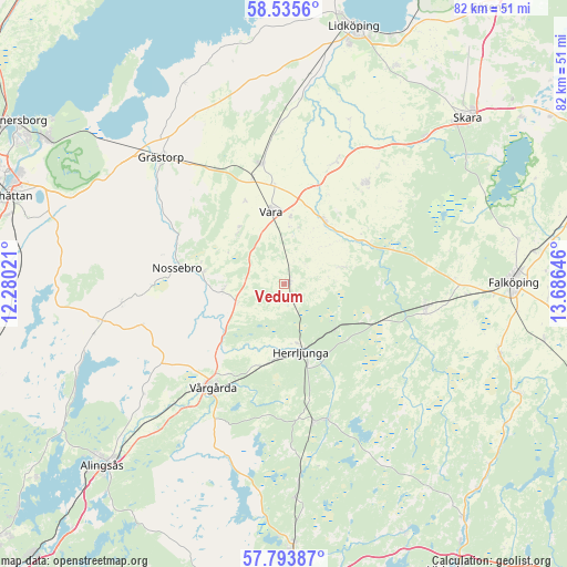
Vedum GPS coordinates[2]
58° 10' 0.012" North, 12° 58' 59.988" East
| Map corner | latitude | longitude |
|---|---|---|
| Upper-left | 58.5356°, | 12.28021° |
| Center: | 58.16667°, | 12.98333° |
| Lower-right: | 57.79387°, | 13.68646° |
| Map W x H: | 82.5×82.5 km | = 51.3×51.3mi |
| max Lat: | 67.85572° ⇑58.4% North |
| Vedum: | 58.16667° |
| min Lat: | ⇓41.6% South 55.34337° |
| min Long | Vedum | max Long |
| 11.1712° | 12.98333° | 24.13676° |
| W 19.7%⇐ | ⇒80.3% E |
Elevation
Elevation of Vedum is 111 m = 364 ft, and this is 28.4 m = 93 ft above average elevation for this country.
| Max E: |
663 m = 2175 ft | 26.6% |
| Vedum | 111 m 364 ft | |
| Avg. | 82.6 m = 271 ft | |
Min E: |
-1 m = -3 ft | 73.4% |
See also: Sweden elevation on elevation.city.
Geographical zone
Vedum is located in North temperate zone (between Tropic of Cancer and the Arctic Circle). Distance of this North polar circle is 933.6 km =580.1 mi to North.| Distance of | km | miles | from Vedum |
|---|---|---|---|
| North Pole | 3539.5 | 2199.3 | to North |
| Arctic Circle | 933.6 | 580.1 | to North |
| Tropic Cancer | 3861.6 | 2399.5 | to South |
| Equator | 6467.5 | 4018.7 | to South |


Nearby cities:
15 places around Vedum: (largest is in red/bold)
• Annelund
20.5 km =12.7 mi,  164°
164°
• Ardala
29.9 km =18.6 mi,  43°
43°
• Floby
20.9 km =13 mi,  100°
100°
• Grästorp
25.5 km =15.8 mi,  316°
316°
• Herrljunga
10.2 km =6.3 mi,  165°
165°
• Jonstorp
24.3 km =15.1 mi,  220°
220°
• Järpås
24.1 km =15 mi,  357°
357°
• Kinnarp
33.1 km =20.6 mi,  107°
107°
• Kvänum
18.9 km =11.7 mi, 38°
• Ljung
20.5 km =12.7 mi, 167°
• Nossebro
15.9 km =9.9 mi,  278°
278°
• Sollebrunn
27 km =16.8 mi,  258°
258°
• Stora Levene
17.9 km =11.1 mi,  349°
349°
• Vara
10.8 km =6.7 mi, 350°
• Vårgårda
17.7 km =11 mi, 215°
Sources, notices
• [Note1] Compared only with cities in Sweden existing in our database
• [Src1] Map data: © OpenStreetMap contributors (CC-BY-SA)
• [Src2] Other city data from geonames.org with taken over terms of usage.
• [Src3] Geographical zone / Annual Mean Temperature by Robert A. Rohde @ Wikipedia
