Sollebrunn geodata
Sollebrunn (Västra Götaland) is a populated place; located in Sweden in Europe/Stockholm (GMT+2) time zone. With population of 1,482 people, there are 662 cities with bigger population in this country. Compared to other cities in Sweden, 59% of cities are located further ↑North; 88.1% of cities are located further →East and 63.2% of cities have lower elevation than Sollebrunn. Note1


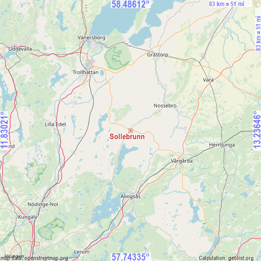
Sollebrunn GPS coordinates[2]
58° 7' 0.012" North, 12° 31' 59.988" East
| Map corner | latitude | longitude |
|---|---|---|
| Upper-left | 58.48612°, | 11.83021° |
| Center: | 58.11667°, | 12.53333° |
| Lower-right: | 57.74335°, | 13.23646° |
| Map W x H: | 82.6×82.6 km | = 51.3×51.3mi |
| max Lat: | 67.85572° ⇑59% North |
| Sollebrunn: | 58.11667° |
| min Lat: | ⇓41% South 55.34337° |
| min Long | Sollebrunn | max Long |
| 11.1712° | 12.53333° | 24.13676° |
| W 11.9%⇐ | ⇒88.1% E |
Elevation
Elevation of Sollebrunn is 77 m = 253 ft, and this is 5.6 m = 18 ft below average elevation for this country.
| Max E: |
663 m = 2175 ft | 36.8% |
| Avg. | 82.6 m = 271 ft | |
| Sollebrunn | 77 m = 253 ft | |
Min E: |
-1 m = -3 ft | 63.2% |
See also: Sweden elevation on elevation.city.
Geographical zone
Sollebrunn is located in North temperate zone (between Tropic of Cancer and the Arctic Circle). Distance of this North polar circle is 939.2 km =583.6 mi to North.| Distance of | km | miles | from Sollebrunn |
|---|---|---|---|
| North Pole | 3545.1 | 2202.8 | to North |
| Arctic Circle | 939.2 | 583.6 | to North |
| Tropic Cancer | 3856 | 2396 | to South |
| Equator | 6462 | 4015.3 | to South |


Nearby cities:
15 places around Sollebrunn: (largest is in red/bold)
• Alingsås
20.7 km =12.9 mi,  179°
179°
• Glommen
23.1 km =14.4 mi,  207°
207°
• Göta
22.4 km =13.9 mi,  267°
267°
• Jonstorp
16.9 km =10.5 mi,  140°
140°
• Lilla Edet
23.6 km =14.7 mi, 274°
• Lödöse
24 km =14.9 mi,  246°
246°
• Nossebro
13.3 km =8.3 mi,  53°
53°
• Sjuntorp
20.8 km =12.9 mi,  296°
296°
• Sjövik
24.3 km =15.1 mi,  203°
203°
• Skepplanda
24.6 km =15.3 mi,  232°
232°
• Sålanda
23.8 km =14.8 mi, 231°
• Trollhättan
23.5 km =14.6 mi,  322°
322°
• Upphärad
14.2 km =8.8 mi,  288°
288°
• Velanda
18.1 km =11.2 mi,  313°
313°
• Vårgårda
18.5 km =11.5 mi,  118°
118°
Sources, notices
• [Note1] Compared only with cities in Sweden existing in our database
• [Src1] Map data: © OpenStreetMap contributors (CC-BY-SA)
• [Src2] Other city data from geonames.org with taken over terms of usage.
• [Src3] Geographical zone / Annual Mean Temperature by Robert A. Rohde @ Wikipedia
