Jonstorp geodata
Jonstorp (Västra Götaland) is a populated place; located in Sweden in Europe/Stockholm (GMT+2) time zone. With population of 1,771 people, there are 576 cities with bigger population in this country. Compared to other cities in Sweden, 60.4% of cities are located further ↑North; 85.9% of cities are located further →East and 72.3% of cities have lower elevation than Jonstorp. Note1


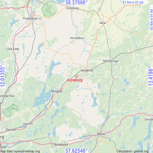
Jonstorp GPS coordinates[2]
58° 0' 0" North, 12° 43' 0.012" East
| Map corner | latitude | longitude |
|---|---|---|
| Upper-left | 58.37066°, | 12.01355° |
| Center: | 58°, | 12.71667° |
| Lower-right: | 57.62546°, | 13.4198° |
| Map W x H: | 82.9×82.9 km | = 51.5×51.5mi |
| max Lat: | 67.85572° ⇑60.4% North |
| Jonstorp: | 58° |
| min Lat: | ⇓39.6% South 55.34337° |
| min Long | Jonstorp | max Long |
| 11.1712° | 12.71667° | 24.13676° |
| W 14.1%⇐ | ⇒85.9% E |
Elevation
Elevation of Jonstorp is 107 m = 351 ft, and this is 24.4 m = 80 ft above average elevation for this country.
| Max E: |
663 m = 2175 ft | 27.7% |
| Jonstorp | 107 m 351 ft | |
| Avg. | 82.6 m = 271 ft | |
Min E: |
-1 m = -3 ft | 72.3% |
See also: Sweden elevation on elevation.city.
Geographical zone
Jonstorp is located in North temperate zone (between Tropic of Cancer and the Arctic Circle). Distance of this North polar circle is 952.2 km =591.7 mi to North.| Distance of | km | miles | from Jonstorp |
|---|---|---|---|
| North Pole | 3558.1 | 2210.9 | to North |
| Arctic Circle | 952.2 | 591.7 | to North |
| Tropic Cancer | 3843.1 | 2388 | to South |
| Equator | 6449 | 4007.2 | to South |


Nearby cities:
15 places around Jonstorp: (largest is in red/bold)
• Alingsås
13.3 km =8.3 mi,  234°
234°
• Annelund
21.1 km =13.1 mi,  93°
93°
• Björboholm
27.2 km =16.9 mi,  238°
238°
• Fristad
26.1 km =16.2 mi,  138°
138°
• Glommen
22.9 km =14.2 mi,  251°
251°
• Herrljunga
20.2 km =12.6 mi,  64°
64°
• Ingared
22.1 km =13.7 mi, 225°
• Ljung
20 km =12.4 mi, 94°
• Nossebro
20.9 km =13 mi,  359°
359°
• Sandhult
26.6 km =16.5 mi,  167°
167°
• Sjövik
22.6 km =14 mi, 245°
• Sollebrunn
16.9 km =10.5 mi,  320°
320°
• Tollered
27 km =16.8 mi,  221°
221°
• Vedum
24.3 km =15.1 mi,  40°
40°
• Vårgårda
6.8 km =4.2 mi,  52°
52°
Sources, notices
• [Note1] Compared only with cities in Sweden existing in our database
• [Src1] Map data: © OpenStreetMap contributors (CC-BY-SA)
• [Src2] Other city data from geonames.org with taken over terms of usage.
• [Src3] Geographical zone / Annual Mean Temperature by Robert A. Rohde @ Wikipedia
