Smedjebacken geodata
Smedjebacken (Dalarna) is a seat of a second-order administrative division; located in Sweden in Europe/Stockholm (GMT+2) time zone. With population of 5,258 people, there are 259 cities with bigger population in this country. Compared to other cities in Sweden, 75% of cities are located further ↓South; 54.6% of cities are located further ←West and 72.1% of cities have lower elevation than Smedjebacken. Note1


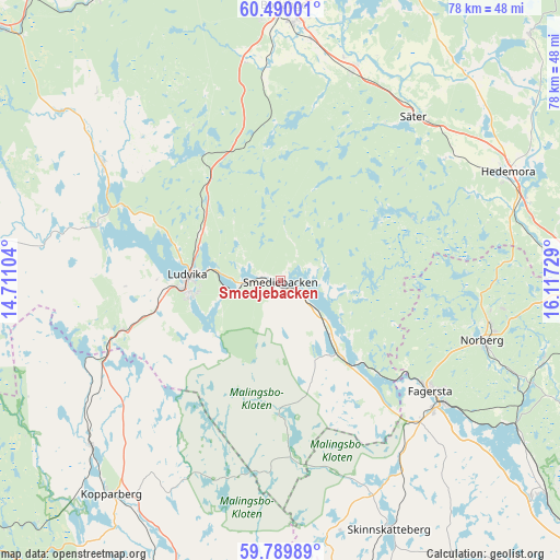
Smedjebacken GPS coordinates[2]
60° 8' 30.516" North, 15° 24' 50.976" East
| Map corner | latitude | longitude |
|---|---|---|
| Upper-left | 60.49001°, | 14.71104° |
| Center: | 60.14181°, | 15.41416° |
| Lower-right: | 59.78989°, | 16.11729° |
| Map W x H: | 77.8×77.8 km | = 48.3×48.3mi |
| max Lat: | 67.85572° ⇑25% North |
| Smedjebacken: | 60.14181° |
| min Lat: | ⇓75% South 55.34337° |
| min Long | Smedjebacken | max Long |
| 11.1712° | 15.41416° | 24.13676° |
| W 54.6%⇐ | ⇒45.4% E |
Elevation
Elevation of Smedjebacken is 105 m = 344 ft, and this is 22.4 m = 73 ft above average elevation for this country.
| Max E: |
663 m = 2175 ft | 27.9% |
| Smedjebacken | 105 m 344 ft | |
| Avg. | 82.6 m = 271 ft | |
Min E: |
-1 m = -3 ft | 72.1% |
See also: Sweden elevation on elevation.city.
Geographical zone
Smedjebacken is located in North temperate zone (between Tropic of Cancer and the Arctic Circle). Distance of this North polar circle is 714 km =443.7 mi to North.| Distance of | km | miles | from Smedjebacken |
|---|---|---|---|
| North Pole | 3319.9 | 2062.9 | to North |
| Arctic Circle | 714 | 443.7 | to North |
| Tropic Cancer | 4081.2 | 2535.9 | to South |
| Equator | 6687.1 | 4155.2 | to South |


Nearby cities:
15 places around Smedjebacken: (largest is in red/bold)
• Abborrberget
34 km =21.1 mi,  271°
271°
• Enbacka
31.4 km =19.5 mi,  18°
18°
• Fagersta
26 km =16.2 mi,  126°
126°
• Grängesberg
23.7 km =14.7 mi,  251°
251°
• Ludvika
12.6 km =7.8 mi, 273°
• Mora
30.5 km =19 mi, 19°
• Norberg
29.5 km =18.3 mi,  106°
106°
• Nyhammar
29.3 km =18.2 mi,  302°
302°
• Romme
32.8 km =20.4 mi,  8°
8°
• Saxdalen
23.7 km =14.7 mi, 271°
• Sunnansjö
27 km =16.8 mi,  287°
287°
• Säter
29.5 km =18.3 mi,  39°
39°
• Söderbärke
11.4 km =7.1 mi, 134°
• Sörvik
15 km =9.3 mi, 288°
• Vikmanshyttan
28.8 km =17.9 mi,  53°
53°
Sources, notices
• [Note1] Compared only with cities in Sweden existing in our database
• [Src1] Map data: © OpenStreetMap contributors (CC-BY-SA)
• [Src2] Other city data from geonames.org with taken over terms of usage.
• [Src3] Geographical zone / Annual Mean Temperature by Robert A. Rohde @ Wikipedia
