Nyhammar geodata
Nyhammar (Dalarna) is a populated place; located in Sweden in Europe/Stockholm (GMT+2) time zone. With population of 1,052 people, there are 786 cities with bigger population in this country. Compared to other cities in Sweden, 76.9% of cities are located further ↓South; 51.5% of cities are located further →East and 86.2% of cities have lower elevation than Nyhammar. Note1


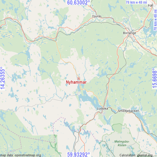
Nyhammar GPS coordinates[2]
60° 16' 59.988" North, 14° 58' 0.012" East
| Map corner | latitude | longitude |
|---|---|---|
| Upper-left | 60.63002°, | 14.26355° |
| Center: | 60.28333°, | 14.96667° |
| Lower-right: | 59.93292°, | 15.6698° |
| Map W x H: | 77.5×77.5 km | = 48.2×48.2mi |
| max Lat: | 67.85572° ⇑23.1% North |
| Nyhammar: | 60.28333° |
| min Lat: | ⇓76.9% South 55.34337° |
| min Long | Nyhammar | max Long |
| 11.1712° | 14.96667° | 24.13676° |
| W 48.5%⇐ | ⇒51.5% E |
Elevation
Elevation of Nyhammar is 174 m = 571 ft, and this is 91.4 m = 300 ft above average elevation for this country.
| Max E: |
663 m = 2175 ft | 13.8% |
| Nyhammar | 174 m 571 ft | |
| Avg. | 82.6 m = 271 ft | |
Min E: |
-1 m = -3 ft | 86.2% |
See also: Sweden elevation on elevation.city.
Geographical zone
Nyhammar is located in North temperate zone (between Tropic of Cancer and the Arctic Circle). Distance of this North polar circle is 698.3 km =433.9 mi to North.| Distance of | km | miles | from Nyhammar |
|---|---|---|---|
| North Pole | 3304.2 | 2053.1 | to North |
| Arctic Circle | 698.3 | 433.9 | to North |
| Tropic Cancer | 4097 | 2545.8 | to South |
| Equator | 6702.9 | 4165 | to South |


Nearby cities:
15 places around Nyhammar: (largest is in red/bold)
• Abborrberget
17.5 km =10.9 mi,  211°
211°
• Björbo
23.9 km =14.9 mi,  324°
324°
• Borlänge
34.3 km =21.3 mi,  48°
48°
• Bäsna
30.6 km =19 mi,  24°
24°
• Djurmo
32 km =19.9 mi, 21°
• Djurås
32.2 km =20 mi, 16°
• Floda
26.5 km =16.5 mi,  338°
338°
• Grängesberg
23.3 km =14.5 mi,  174°
174°
• Ludvika
19.2 km =11.9 mi,  140°
140°
• Mockfjärd
24.1 km =15 mi,  0°
0°
• Romme
33.7 km =20.9 mi,  60°
60°
• Saxdalen
15.2 km =9.4 mi,  176°
176°
• Smedjebacken
29.3 km =18.2 mi,  122°
122°
• Sunnansjö
7.5 km =4.7 mi,  187°
187°
• Sörvik
15.2 km =9.4 mi, 136°
Sources, notices
• [Note1] Compared only with cities in Sweden existing in our database
• [Src1] Map data: © OpenStreetMap contributors (CC-BY-SA)
• [Src2] Other city data from geonames.org with taken over terms of usage.
• [Src3] Geographical zone / Annual Mean Temperature by Robert A. Rohde @ Wikipedia
