Abborrberget geodata
Abborrberget (Dalarna) is a populated place; located in Sweden in Europe/Stockholm (GMT+2) time zone. With population of 1,814 people, there are 565 cities with bigger population in this country. Compared to other cities in Sweden, 75.3% of cities are located further ↓South; 53.4% of cities are located further →East and 96.1% of cities have lower elevation than Abborrberget. Note1


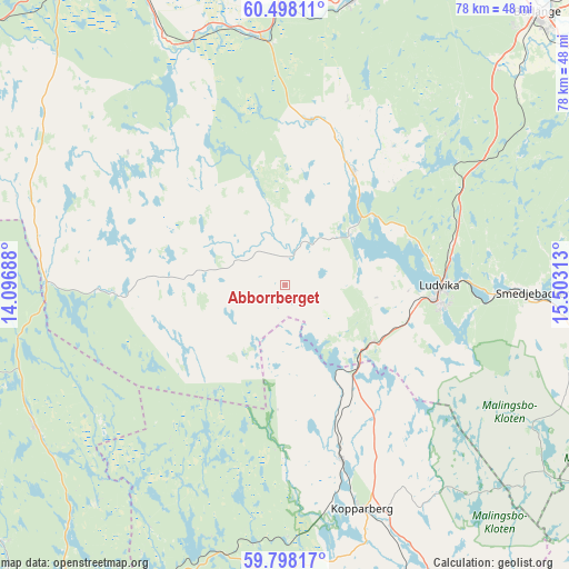
Abborrberget GPS coordinates[2]
60° 9' 0" North, 14° 48' 0" East
| Map corner | latitude | longitude |
|---|---|---|
| Upper-left | 60.49811°, | 14.09688° |
| Center: | 60.15°, | 14.8° |
| Lower-right: | 59.79817°, | 15.50313° |
| Map W x H: | 77.8×77.8 km | = 48.3×48.3mi |
| max Lat: | 67.85572° ⇑24.7% North |
| Abborrberget: | 60.15° |
| min Lat: | ⇓75.3% South 55.34337° |
| min Long | Abborrberget | max Long |
| 11.1712° | 14.8° | 24.13676° |
| W 46.6%⇐ | ⇒53.4% E |
Elevation
Elevation of Abborrberget is 300 m = 984 ft, and this is 217.4 m = 713 ft above average elevation for this country.
| Max E: |
663 m = 2175 ft | 3.9% |
| Abborrberget | 300 m 984 ft | |
| Avg. | 82.6 m = 271 ft | |
Min E: |
-1 m = -3 ft | 96.1% |
See also: Sweden elevation on elevation.city.
Geographical zone
Abborrberget is located in North temperate zone (between Tropic of Cancer and the Arctic Circle). Distance of this North polar circle is 713.1 km =443.1 mi to North.| Distance of | km | miles | from Abborrberget |
|---|---|---|---|
| North Pole | 3319 | 2062.3 | to North |
| Arctic Circle | 713.1 | 443.1 | to North |
| Tropic Cancer | 4082.1 | 2536.5 | to South |
| Equator | 6688.1 | 4155.8 | to South |


Nearby cities:
15 places around Abborrberget: (largest is in red/bold)
• Björbo
34.7 km =21.6 mi,  352°
352°
• Floda
39.6 km =24.6 mi,  359°
359°
• Fredriksberg
23.1 km =14.4 mi,  265°
265°
• Grängesberg
14.2 km =8.8 mi,  126°
126°
• Hällefors
43.5 km =27 mi,  200°
200°
• Kopparberg
32.3 km =20.1 mi,  160°
160°
• Lesjöfors
39.3 km =24.4 mi,  240°
240°
• Ludvika
21.5 km =13.4 mi,  90°
90°
• Mockfjärd
40 km =24.9 mi,  13°
13°
• Nyhammar
17.5 km =10.9 mi,  31°
31°
• Saxdalen
10.3 km =6.4 mi, 91°
• Smedjebacken
34 km =21.1 mi, 91°
• Sunnansjö
11.1 km =6.9 mi,  48°
48°
• Söderbärke
43.1 km =26.8 mi,  101°
101°
• Sörvik
20.1 km =12.5 mi,  79°
79°
Sources, notices
• [Note1] Compared only with cities in Sweden existing in our database
• [Src1] Map data: © OpenStreetMap contributors (CC-BY-SA)
• [Src2] Other city data from geonames.org with taken over terms of usage.
• [Src3] Geographical zone / Annual Mean Temperature by Robert A. Rohde @ Wikipedia
