Fagersta geodata
Fagersta (Västmanland) is a seat of a second-order administrative division; located in Sweden in Europe/Stockholm (GMT+2) time zone. With population of 11,936 people, there are 131 cities with bigger population in this country. Compared to other cities in Sweden, 73.6% of cities are located further ↓South; 59.3% of cities are located further ←West and 73.3% of cities have lower elevation than Fagersta. Note1


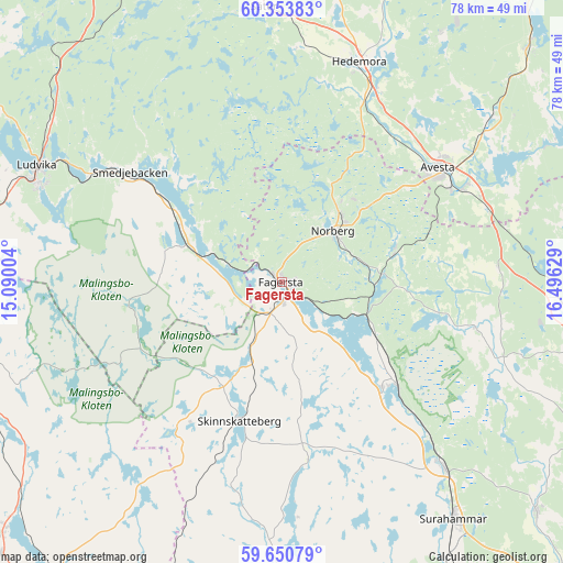
Fagersta GPS coordinates[2]
60° 0' 15.048" North, 15° 47' 35.376" East
| Map corner | latitude | longitude |
|---|---|---|
| Upper-left | 60.35383°, | 15.09004° |
| Center: | 60.00418°, | 15.79316° |
| Lower-right: | 59.65079°, | 16.49629° |
| Map W x H: | 78.2×78.2 km | = 48.6×48.6mi |
| max Lat: | 67.85572° ⇑26.4% North |
| Fagersta: | 60.00418° |
| min Lat: | ⇓73.6% South 55.34337° |
| min Long | Fagersta | max Long |
| 11.1712° | 15.79316° | 24.13676° |
| W 59.3%⇐ | ⇒40.7% E |
Elevation
Elevation of Fagersta is 110 m = 361 ft, and this is 27.4 m = 90 ft above average elevation for this country.
| Max E: |
663 m = 2175 ft | 26.7% |
| Fagersta | 110 m 361 ft | |
| Avg. | 82.6 m = 271 ft | |
Min E: |
-1 m = -3 ft | 73.3% |
See also: Sweden elevation on elevation.city.
Geographical zone
Fagersta is located in North temperate zone (between Tropic of Cancer and the Arctic Circle). Distance of this North polar circle is 729.3 km =453.2 mi to North.| Distance of | km | miles | from Fagersta |
|---|---|---|---|
| North Pole | 3335.2 | 2072.4 | to North |
| Arctic Circle | 729.3 | 453.2 | to North |
| Tropic Cancer | 4065.9 | 2526.4 | to South |
| Equator | 6671.8 | 4145.7 | to South |


Nearby cities:
15 places around Fagersta: (largest is in red/bold)
• Annelund
13.4 km =8.3 mi,  91°
91°
• Avesta
25.7 km =16 mi,  53°
53°
• Brunna
31.1 km =19.3 mi,  22°
22°
• Fors
36.4 km =22.6 mi, 51°
• Hedemora
32.5 km =20.2 mi, 19°
• Krylbo
27.5 km =17.1 mi,  58°
58°
• Norberg
9.9 km =6.2 mi, 46°
• Ramnäs
34.8 km =21.6 mi,  139°
139°
• Råby
33.6 km =20.9 mi,  71°
71°
• Sjövik
33.3 km =20.7 mi, 60°
• Skinnskatteberg
20.1 km =12.5 mi,  196°
196°
• Smedjebacken
26 km =16.2 mi,  306°
306°
• Söderbärke
14.9 km =9.3 mi,  299°
299°
• Vikmanshyttan
32.7 km =20.3 mi,  3°
3°
• Västerfärnebo
27.7 km =17.2 mi,  103°
103°
Sources, notices
• [Note1] Compared only with cities in Sweden existing in our database
• [Src1] Map data: © OpenStreetMap contributors (CC-BY-SA)
• [Src2] Other city data from geonames.org with taken over terms of usage.
• [Src3] Geographical zone / Annual Mean Temperature by Robert A. Rohde @ Wikipedia
