Sandhult geodata
Sandhult (Västra Götaland) is a populated place; located in Sweden in Europe/Stockholm (GMT+2) time zone. With population of 563 people, there are 1215 cities with bigger population in this country. Compared to other cities in Sweden, 65.5% of cities are located further ↑North; 84.3% of cities are located further →East and 93.6% of cities have lower elevation than Sandhult. Note1


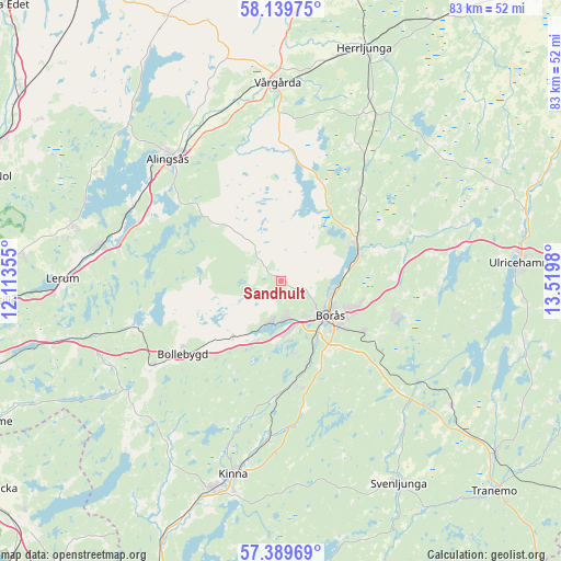
Sandhult GPS coordinates[2]
57° 46' 0.012" North, 12° 49' 0.012" East
| Map corner | latitude | longitude |
|---|---|---|
| Upper-left | 58.13975°, | 12.11355° |
| Center: | 57.76667°, | 12.81667° |
| Lower-right: | 57.38969°, | 13.5198° |
| Map W x H: | 83.4×83.4 km | = 51.8×51.8mi |
| max Lat: | 67.85572° ⇑65.5% North |
| Sandhult: | 57.76667° |
| min Lat: | ⇓34.5% South 55.34337° |
| min Long | Sandhult | max Long |
| 11.1712° | 12.81667° | 24.13676° |
| W 15.7%⇐ | ⇒84.3% E |
Elevation
Elevation of Sandhult is 232 m = 761 ft, and this is 149.4 m = 490 ft above average elevation for this country.
| Max E: |
663 m = 2175 ft | 6.4% |
| Sandhult | 232 m 761 ft | |
| Avg. | 82.6 m = 271 ft | |
Min E: |
-1 m = -3 ft | 93.6% |
See also: Sweden elevation on elevation.city.
Geographical zone
Sandhult is located in North temperate zone (between Tropic of Cancer and the Arctic Circle). Distance of this North polar circle is 978.1 km =607.8 mi to North.| Distance of | km | miles | from Sandhult |
|---|---|---|---|
| North Pole | 3584 | 2227 | to North |
| Arctic Circle | 978.1 | 607.8 | to North |
| Tropic Cancer | 3817.1 | 2371.8 | to South |
| Equator | 6423.1 | 3991.1 | to South |


Nearby cities:
15 places around Sandhult: (largest is in red/bold)
• Bollebygd
18.1 km =11.2 mi,  233°
233°
• Borås
8.9 km =5.5 mi,  124°
124°
• Dalsjöfors
16.8 km =10.4 mi,  109°
109°
• Fristad
13.2 km =8.2 mi,  60°
60°
• Frufällan
9.1 km =5.7 mi,  78°
78°
• Gånghester
14 km =8.7 mi, 121°
• Hindås
23.1 km =14.4 mi,  252°
252°
• Målsryd
16.7 km =10.4 mi, 123°
• Olsfors
11 km =6.8 mi,  219°
219°
• Rydboholm
13.6 km =8.5 mi,  163°
163°
• Rävlanda
22.7 km =14.1 mi,  236°
236°
• Sandared
6.5 km =4 mi,  192°
192°
• Sjömarken
5.8 km =3.6 mi,  169°
169°
• Svaneholm
16.7 km =10.4 mi,  180°
180°
• Viskafors
15.4 km =9.6 mi, 172°
Sources, notices
• [Note1] Compared only with cities in Sweden existing in our database
• [Src1] Map data: © OpenStreetMap contributors (CC-BY-SA)
• [Src2] Other city data from geonames.org with taken over terms of usage.
• [Src3] Geographical zone / Annual Mean Temperature by Robert A. Rohde @ Wikipedia
