Bollebygd geodata
Bollebygd (Västra Götaland) is a seat of a second-order administrative division; located in Sweden in Europe/Stockholm (GMT+2) time zone. With population of 3,870 people, there are 333 cities with bigger population in this country. Compared to other cities in Sweden, 68.6% of cities are located further ↑North; 87.5% of cities are located further →East and 66.2% of cities have lower elevation than Bollebygd. Note1


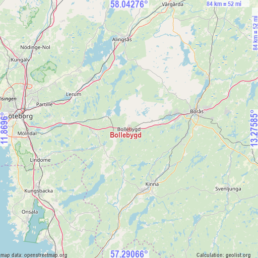
Bollebygd GPS coordinates[2]
57° 40' 7.176" North, 12° 34' 21.792" East
| Map corner | latitude | longitude |
|---|---|---|
| Upper-left | 58.04276°, | 11.8696° |
| Center: | 57.66866°, | 12.57272° |
| Lower-right: | 57.29066°, | 13.27585° |
| Map W x H: | 83.6×83.6 km | = 51.9×51.9mi |
| max Lat: | 67.85572° ⇑68.6% North |
| Bollebygd: | 57.66866° |
| min Lat: | ⇓31.4% South 55.34337° |
| min Long | Bollebygd | max Long |
| 11.1712° | 12.57272° | 24.13676° |
| W 12.5%⇐ | ⇒87.5% E |
Elevation
Elevation of Bollebygd is 87 m = 285 ft, and this is 4.4 m = 14 ft above average elevation for this country.
| Max E: |
663 m = 2175 ft | 33.8% |
| Bollebygd | 87 m 285 ft | |
| Avg. | 82.6 m = 271 ft | |
Min E: |
-1 m = -3 ft | 66.2% |
See also: Sweden elevation on elevation.city.
Geographical zone
Bollebygd is located in North temperate zone (between Tropic of Cancer and the Arctic Circle). Distance of this North polar circle is 989 km =614.5 mi to North.| Distance of | km | miles | from Bollebygd |
|---|---|---|---|
| North Pole | 3594.9 | 2233.8 | to North |
| Arctic Circle | 989 | 614.5 | to North |
| Tropic Cancer | 3806.2 | 2365.1 | to South |
| Equator | 6412.2 | 3984.4 | to South |


Nearby cities:
15 places around Bollebygd: (largest is in red/bold)
• Fritsla
17.7 km =11 mi,  134°
134°
• Hindås
8.4 km =5.2 mi,  297°
297°
• Hyssna
12.6 km =7.8 mi,  189°
189°
• Härryda
12.6 km =7.8 mi,  262°
262°
• Olsfors
7.8 km =4.8 mi,  71°
71°
• Rydboholm
18.6 km =11.6 mi,  96°
96°
• Rävlanda
4.8 km =3 mi,  249°
249°
• Sandared
13.8 km =8.6 mi, 70°
• Sandhult
18.1 km =11.2 mi,  53°
53°
• Sjömarken
16.4 km =10.2 mi, 71°
• Svaneholm
15.6 km =9.7 mi,  111°
111°
• Sätila
16.3 km =10.1 mi,  210°
210°
• Tollered
18.9 km =11.7 mi,  330°
330°
• Viskafors
17 km =10.6 mi, 104°
• Öxeryd
19 km =11.8 mi,  293°
293°
Sources, notices
• [Note1] Compared only with cities in Sweden existing in our database
• [Src1] Map data: © OpenStreetMap contributors (CC-BY-SA)
• [Src2] Other city data from geonames.org with taken over terms of usage.
• [Src3] Geographical zone / Annual Mean Temperature by Robert A. Rohde @ Wikipedia
