Rävlanda geodata
Rävlanda (Västra Götaland) is a populated place; located in Sweden in Europe/Stockholm (GMT+2) time zone. With population of 1,522 people, there are 650 cities with bigger population in this country. Compared to other cities in Sweden, 69.3% of cities are located further ↑North; 88.4% of cities are located further →East and 57.9% of cities have lower elevation than Rävlanda. Note1
Administrative division(s):
- Level 1: Västra Götaland
- Level 2: Härryda Kommun
- Level 3: Björketorp
- Level 4: Björketorp socken


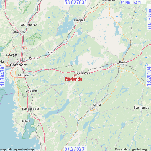
Rävlanda GPS coordinates[2]
57° 39' 12.168" North, 12° 29' 52.476" East
| Map corner | latitude | longitude |
|---|---|---|
| Upper-left | 58.02763°, | 11.79479° |
| Center: | 57.65338°, | 12.49791° |
| Lower-right: | 57.27523°, | 13.20104° |
| Map W x H: | 83.7×83.7 km | = 52×52mi |
| max Lat: | 67.85572° ⇑69.3% North |
| Rävlanda: | 57.65338° |
| min Lat: | ⇓30.7% South 55.34337° |
| min Long | Rävlanda | max Long |
| 11.1712° | 12.49791° | 24.13676° |
| W 11.6%⇐ | ⇒88.4% E |
Elevation
Elevation of Rävlanda is 65 m = 213 ft, and this is 17.6 m = 58 ft below average elevation for this country.
| Max E: |
663 m = 2175 ft | 42.1% |
| Avg. | 82.6 m = 271 ft | |
| Rävlanda | 65 m = 213 ft | |
Min E: |
-1 m = -3 ft | 57.9% |
See also: Sweden elevation on elevation.city.
Geographical zone
Rävlanda is located in North temperate zone (between Tropic of Cancer and the Arctic Circle). Distance of this North polar circle is 990.7 km =615.6 mi to North.| Distance of | km | miles | from Rävlanda |
|---|---|---|---|
| North Pole | 3596.6 | 2234.8 | to North |
| Arctic Circle | 990.7 | 615.6 | to North |
| Tropic Cancer | 3804.5 | 2364 | to South |
| Equator | 6410.5 | 3983.3 | to South |


Nearby cities:
15 places around Rävlanda: (largest is in red/bold)
• Bollebygd
4.8 km =3 mi,  69°
69°
• Fritsla
20.2 km =12.6 mi,  122°
122°
• Hindås
6.3 km =3.9 mi,  331°
331°
• Hyssna
11 km =6.8 mi,  167°
167°
• Härryda
8 km =5 mi,  270°
270°
• Kinna
20 km =12.4 mi,  144°
144°
• Landvetter
17.4 km =10.8 mi,  282°
282°
• Lerum
18.8 km =11.7 mi,  313°
313°
• Olsfors
12.6 km =7.8 mi, 70°
• Sandared
18.6 km =11.6 mi, 70°
• Stenkullen
19 km =11.8 mi, 325°
• Svaneholm
19.4 km =12.1 mi,  102°
102°
• Sätila
13 km =8.1 mi,  196°
196°
• Tollered
18.8 km =11.7 mi,  345°
345°
• Öxeryd
15.9 km =9.9 mi, 305°
Sources, notices
• [Note1] Compared only with cities in Sweden existing in our database
• [Src1] Map data: © OpenStreetMap contributors (CC-BY-SA)
• [Src2] Other city data from geonames.org with taken over terms of usage.
• [Src3] Geographical zone / Annual Mean Temperature by Robert A. Rohde @ Wikipedia
