Åtvidaberg geodata
Åtvidaberg (Östergötland) is a seat of a second-order administrative division; located in Sweden in Europe/Stockholm (GMT+2) time zone. With population of 7,014 people, there are 208 cities with bigger population in this country. Compared to other cities in Sweden, 57.8% of cities are located further ↑North; 61.8% of cities are located further ←West and 68.5% of cities have lower elevation than Åtvidaberg. Note1


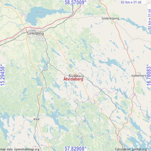
Åtvidaberg GPS coordinates[2]
58° 12' 5.472" North, 15° 59' 51.72" East
| Map corner | latitude | longitude |
|---|---|---|
| Upper-left | 58.57009°, | 15.29458° |
| Center: | 58.20152°, | 15.9977° |
| Lower-right: | 57.82908°, | 16.70083° |
| Map W x H: | 82.4×82.4 km | = 51.2×51.2mi |
| max Lat: | 67.85572° ⇑57.8% North |
| Åtvidaberg: | 58.20152° |
| min Lat: | ⇓42.2% South 55.34337° |
| min Long | Åtvidaberg | max Long |
| 11.1712° | 15.9977° | 24.13676° |
| W 61.8%⇐ | ⇒38.2% E |
Elevation
Elevation of Åtvidaberg is 94 m = 308 ft, and this is 11.4 m = 37 ft above average elevation for this country.
| Max E: |
663 m = 2175 ft | 31.5% |
| Åtvidaberg | 94 m 308 ft | |
| Avg. | 82.6 m = 271 ft | |
Min E: |
-1 m = -3 ft | 68.5% |
See also: Sweden elevation on elevation.city.
Geographical zone
Åtvidaberg is located in North temperate zone (between Tropic of Cancer and the Arctic Circle). Distance of this North polar circle is 929.8 km =577.8 mi to North.| Distance of | km | miles | from Åtvidaberg |
|---|---|---|---|
| North Pole | 3535.7 | 2197 | to North |
| Arctic Circle | 929.8 | 577.8 | to North |
| Tropic Cancer | 3865.5 | 2401.9 | to South |
| Equator | 6471.4 | 4021.1 | to South |


Nearby cities:
15 places around Åtvidaberg: (largest is in red/bold)
• Askeby
24.5 km =15.2 mi,  339°
339°
• Bestorp
15.9 km =9.9 mi,  282°
282°
• Grebo
13.4 km =8.3 mi,  326°
326°
• Gusum
30.3 km =18.8 mi,  75°
75°
• Horn
34.9 km =21.7 mi,  196°
196°
• Kisa
32 km =19.9 mi,  222°
222°
• Linghem
28.7 km =17.8 mi, 334°
• Linköping
32 km =19.9 mi,  316°
316°
• Norsholm
33.8 km =21 mi,  357°
357°
• Rimforsa
19.6 km =12.2 mi,  248°
248°
• Ringarum
30.2 km =18.8 mi,  61°
61°
• Slaka
32 km =19.9 mi,  305°
305°
• Sturefors
21.3 km =13.2 mi, 313°
• Tallboda
31 km =19.3 mi, 323°
• Överum
30.1 km =18.7 mi,  141°
141°
Sources, notices
• [Note1] Compared only with cities in Sweden existing in our database
• [Src1] Map data: © OpenStreetMap contributors (CC-BY-SA)
• [Src2] Other city data from geonames.org with taken over terms of usage.
• [Src3] Geographical zone / Annual Mean Temperature by Robert A. Rohde @ Wikipedia
