Grebo geodata
Grebo (Östergötland) is a populated place; located in Sweden in Europe/Stockholm (GMT+2) time zone. With population of 1,047 people, there are 790 cities with bigger population in this country. Compared to other cities in Sweden, 56.5% of cities are located further ↑North; 60.7% of cities are located further ←West and 66.6% of cities have lower elevation than Grebo. Note1


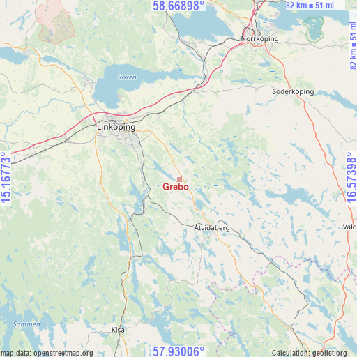
Grebo GPS coordinates[2]
58° 18' 5.22" North, 15° 52' 15.06" East
| Map corner | latitude | longitude |
|---|---|---|
| Upper-left | 58.66898°, | 15.16773° |
| Center: | 58.30145°, | 15.87085° |
| Lower-right: | 57.93006°, | 16.57398° |
| Map W x H: | 82.2×82.2 km | = 51.1×51.1mi |
| max Lat: | 67.85572° ⇑56.5% North |
| Grebo: | 58.30145° |
| min Lat: | ⇓43.5% South 55.34337° |
| min Long | Grebo | max Long |
| 11.1712° | 15.87085° | 24.13676° |
| W 60.7%⇐ | ⇒39.3% E |
Elevation
Elevation of Grebo is 88 m = 289 ft, and this is 5.4 m = 18 ft above average elevation for this country.
| Max E: |
663 m = 2175 ft | 33.4% |
| Grebo | 88 m 289 ft | |
| Avg. | 82.6 m = 271 ft | |
Min E: |
-1 m = -3 ft | 66.6% |
See also: Sweden elevation on elevation.city.
Geographical zone
Grebo is located in North temperate zone (between Tropic of Cancer and the Arctic Circle). Distance of this North polar circle is 918.7 km =570.9 mi to North.| Distance of | km | miles | from Grebo |
|---|---|---|---|
| North Pole | 3524.5 | 2190 | to North |
| Arctic Circle | 918.7 | 570.9 | to North |
| Tropic Cancer | 3876.6 | 2408.8 | to South |
| Equator | 6482.5 | 4028 | to South |


Nearby cities:
15 places around Grebo: (largest is in red/bold)
• Askeby
11.9 km =7.4 mi,  353°
353°
• Berg
28.8 km =17.9 mi,  316°
316°
• Bestorp
11 km =6.8 mi,  226°
226°
• Ekängen
23 km =14.3 mi, 322°
• Kimstad
28.1 km =17.5 mi,  10°
10°
• Linghem
15.5 km =9.6 mi,  340°
340°
• Linköping
19 km =11.8 mi,  309°
309°
• Malmslätt
24 km =14.9 mi,  300°
300°
• Norsholm
23.4 km =14.5 mi, 14°
• Rimforsa
21.3 km =13.2 mi,  210°
210°
• Slaka
20.1 km =12.5 mi,  291°
291°
• Sturefors
8.8 km =5.5 mi, 293°
• Tallboda
17.6 km =10.9 mi, 321°
• Vikingstad
27.2 km =16.9 mi, 289°
• Åtvidaberg
13.4 km =8.3 mi,  146°
146°
Sources, notices
• [Note1] Compared only with cities in Sweden existing in our database
• [Src1] Map data: © OpenStreetMap contributors (CC-BY-SA)
• [Src2] Other city data from geonames.org with taken over terms of usage.
• [Src3] Geographical zone / Annual Mean Temperature by Robert A. Rohde @ Wikipedia
