Kisa geodata
Kisa (Östergötland) is a seat of a second-order administrative division; located in Sweden in Europe/Stockholm (GMT+2) time zone. With population of 3,776 people, there are 342 cities with bigger population in this country. Compared to other cities in Sweden, 60.7% of cities are located further ↑North; 57.5% of cities are located further ←West and 72.9% of cities have lower elevation than Kisa. Note1


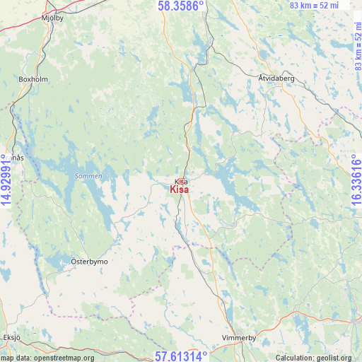
Kisa GPS coordinates[2]
57° 59' 16.116" North, 15° 37' 58.908" East
| Map corner | latitude | longitude |
|---|---|---|
| Upper-left | 58.3586°, | 14.92991° |
| Center: | 57.98781°, | 15.63303° |
| Lower-right: | 57.61314°, | 16.33616° |
| Map W x H: | 82.9×82.9 km | = 51.5×51.5mi |
| max Lat: | 67.85572° ⇑60.7% North |
| Kisa: | 57.98781° |
| min Lat: | ⇓39.3% South 55.34337° |
| min Long | Kisa | max Long |
| 11.1712° | 15.63303° | 24.13676° |
| W 57.5%⇐ | ⇒42.5% E |
Elevation
Elevation of Kisa is 108 m = 354 ft, and this is 25.4 m = 83 ft above average elevation for this country.
| Max E: |
663 m = 2175 ft | 27.1% |
| Kisa | 108 m 354 ft | |
| Avg. | 82.6 m = 271 ft | |
Min E: |
-1 m = -3 ft | 72.9% |
See also: Sweden elevation on elevation.city.
Geographical zone
Kisa is located in North temperate zone (between Tropic of Cancer and the Arctic Circle). Distance of this North polar circle is 953.5 km =592.5 mi to North.| Distance of | km | miles | from Kisa |
|---|---|---|---|
| North Pole | 3559.4 | 2211.7 | to North |
| Arctic Circle | 953.5 | 592.5 | to North |
| Tropic Cancer | 3841.7 | 2387.1 | to South |
| Equator | 6447.6 | 4006.4 | to South |


Nearby cities:
15 places around Kisa: (largest is in red/bold)
• Bestorp
27.9 km =17.3 mi,  12°
12°
• Boxholm
41.2 km =25.6 mi,  304°
304°
• Grebo
37.6 km =23.4 mi,  21°
21°
• Gullringen
21.3 km =13.2 mi,  169°
169°
• Horn
15.3 km =9.5 mi,  129°
129°
• Lidhult
14.4 km =8.9 mi,  252°
252°
• Mariannelund
41.5 km =25.8 mi,  185°
185°
• Rimforsa
16.8 km =10.4 mi, 10°
• Sturefors
38.9 km =24.2 mi, 8°
• Södra Vi
29.2 km =18.1 mi,  160°
160°
• Tranås
39 km =24.2 mi,  278°
278°
• Vimmerby
38.1 km =23.7 mi, 159°
• Åtvidaberg
32 km =19.9 mi,  42°
42°
• Österbymo
27.9 km =17.3 mi,  229°
229°
• Överum
40.1 km =24.9 mi,  89°
89°
Sources, notices
• [Note1] Compared only with cities in Sweden existing in our database
• [Src1] Map data: © OpenStreetMap contributors (CC-BY-SA)
• [Src2] Other city data from geonames.org with taken over terms of usage.
• [Src3] Geographical zone / Annual Mean Temperature by Robert A. Rohde @ Wikipedia
