Perstorp geodata
Perstorp (Skåne) is a seat of a second-order administrative division; located in Sweden in Europe/Stockholm (GMT+2) time zone. With population of 5,847 people, there are 242 cities with bigger population in this country. Compared to other cities in Sweden, 89.6% of cities are located further ↑North; 73% of cities are located further →East and 68% of cities have lower elevation than Perstorp. Note1


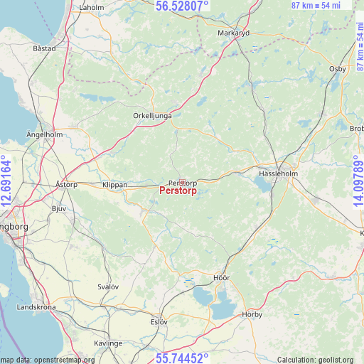
Perstorp GPS coordinates[2]
56° 8' 17.844" North, 13° 23' 41.136" East
| Map corner | latitude | longitude |
|---|---|---|
| Upper-left | 56.52807°, | 12.69164° |
| Center: | 56.13829°, | 13.39476° |
| Lower-right: | 55.74452°, | 14.09789° |
| Map W x H: | 87.1×87.1 km | = 54.1×54.1mi |
| max Lat: | 67.85572° ⇑89.6% North |
| Perstorp: | 56.13829° |
| min Lat: | ⇓10.4% South 55.34337° |
| min Long | Perstorp | max Long |
| 11.1712° | 13.39476° | 24.13676° |
| W 27%⇐ | ⇒73% E |
Elevation
Elevation of Perstorp is 93 m = 305 ft, and this is 10.4 m = 34 ft above average elevation for this country.
| Max E: |
663 m = 2175 ft | 32% |
| Perstorp | 93 m 305 ft | |
| Avg. | 82.6 m = 271 ft | |
Min E: |
-1 m = -3 ft | 68% |
See also: Sweden elevation on elevation.city.
Geographical zone
Perstorp is located in North temperate zone (between Tropic of Cancer and the Arctic Circle). Distance of this North polar circle is 1159.2 km =720.3 mi to North.| Distance of | km | miles | from Perstorp |
|---|---|---|---|
| North Pole | 3765.1 | 2339.5 | to North |
| Arctic Circle | 1159.2 | 720.3 | to North |
| Tropic Cancer | 3636.1 | 2259.4 | to South |
| Equator | 6242 | 3878.6 | to South |


Nearby cities:
15 places around Perstorp: (largest is in red/bold)
• Finja
18.1 km =11.2 mi,  79°
79°
• Hässleholm
23.1 km =14.4 mi, 84°
• Höör
24.4 km =15.2 mi,  158°
158°
• Klippan
16.4 km =10.2 mi,  268°
268°
• Kvidinge
21.6 km =13.4 mi, 268°
• Ljungbyhed
11.9 km =7.4 mi,  233°
233°
• Röstånga
16.9 km =10.5 mi,  204°
204°
• Stidsvig
17.6 km =10.9 mi,  292°
292°
• Sösdala
20.7 km =12.9 mi,  121°
121°
• Tjörnarp
21.5 km =13.4 mi,  137°
137°
• Tormestorp
21.9 km =13.6 mi,  97°
97°
• Tyringe
12.8 km =8 mi, 78°
• Åsljunga
19.9 km =12.4 mi,  354°
354°
• Örkelljunga
17.7 km =11 mi,  335°
335°
• Östra Ljungby
19.8 km =12.3 mi, 288°
Sources, notices
• [Note1] Compared only with cities in Sweden existing in our database
• [Src1] Map data: © OpenStreetMap contributors (CC-BY-SA)
• [Src2] Other city data from geonames.org with taken over terms of usage.
• [Src3] Geographical zone / Annual Mean Temperature by Robert A. Rohde @ Wikipedia
