Ljungbyhed geodata
Ljungbyhed (Skåne) is a populated place; located in Sweden in Europe/Stockholm (GMT+2) time zone. With population of 2,127 people, there are 505 cities with bigger population in this country. Compared to other cities in Sweden, 91.1% of cities are located further ↑North; 75% of cities are located further →East and 51.8% of cities have higher elevation than Ljungbyhed. Note1


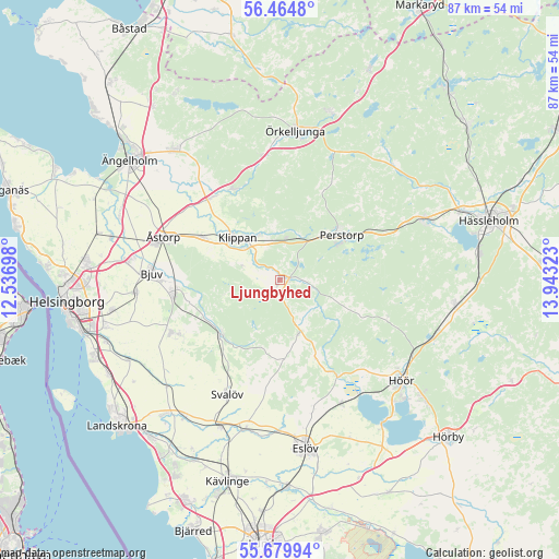
Ljungbyhed GPS coordinates[2]
56° 4' 27.732" North, 13° 14' 24.36" East
| Map corner | latitude | longitude |
|---|---|---|
| Upper-left | 56.4648°, | 12.53698° |
| Center: | 56.07437°, | 13.2401° |
| Lower-right: | 55.67994°, | 13.94323° |
| Map W x H: | 87.3×87.3 km | = 54.2×54.2mi |
| max Lat: | 67.85572° ⇑91.1% North |
| Ljungbyhed: | 56.07437° |
| min Lat: | ⇓8.9% South 55.34337° |
| min Long | Ljungbyhed | max Long |
| 11.1712° | 13.2401° | 24.13676° |
| W 25%⇐ | ⇒75% E |
Elevation
Elevation of Ljungbyhed is 47 m = 154 ft, and this is 35.6 m = 117 ft below average elevation for this country.
| Max E: |
663 m = 2175 ft | 51.8% |
| Avg. | 82.6 m = 271 ft | |
| Ljungbyhed | 47 m = 154 ft | |
Min E: |
-1 m = -3 ft | 48.2% |
See also: Sweden elevation on elevation.city.
Geographical zone
Ljungbyhed is located in North temperate zone (between Tropic of Cancer and the Arctic Circle). Distance of this North polar circle is 1166.3 km =724.7 mi to North.| Distance of | km | miles | from Ljungbyhed |
|---|---|---|---|
| North Pole | 3772.2 | 2343.9 | to North |
| Arctic Circle | 1166.3 | 724.7 | to North |
| Tropic Cancer | 3629 | 2255 | to South |
| Equator | 6234.9 | 3874.2 | to South |


Nearby cities:
15 places around Ljungbyhed: (largest is in red/bold)
• Billesholm
15.1 km =9.4 mi,  259°
259°
• Bjuv
19.9 km =12.4 mi,  272°
272°
• Björnås
18 km =11.2 mi,  288°
288°
• Ekeby
18.9 km =11.7 mi,  244°
244°
• Klippan
9.6 km =6 mi,  315°
315°
• Kvidinge
13.7 km =8.5 mi,  298°
298°
• Kågeröd
12.6 km =7.8 mi,  228°
228°
• Mörarp
22.4 km =13.9 mi, 265°
• Perstorp
11.9 km =7.4 mi,  53°
53°
• Röstånga
8.7 km =5.4 mi,  162°
162°
• Stehag
21.5 km =13.4 mi,  153°
153°
• Stidsvig
15.5 km =9.6 mi,  334°
334°
• Svalöv
19.7 km =12.2 mi,  204°
204°
• Åstorp
19.6 km =12.2 mi, 290°
• Östra Ljungby
16.3 km =10.1 mi, 325°
Sources, notices
• [Note1] Compared only with cities in Sweden existing in our database
• [Src1] Map data: © OpenStreetMap contributors (CC-BY-SA)
• [Src2] Other city data from geonames.org with taken over terms of usage.
• [Src3] Geographical zone / Annual Mean Temperature by Robert A. Rohde @ Wikipedia
