Röstånga geodata
Röstånga (Skåne) is a populated place; located in Sweden in Europe/Stockholm (GMT+2) time zone. With population of 874 people, there are 901 cities with bigger population in this country. Compared to other cities in Sweden, 92.7% of cities are located further ↑North; 74.4% of cities are located further →East and 67.4% of cities have lower elevation than Röstånga. Note1


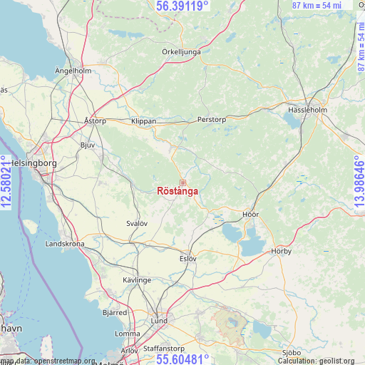
Röstånga GPS coordinates[2]
56° 0' 0" North, 13° 16' 59.988" East
| Map corner | latitude | longitude |
|---|---|---|
| Upper-left | 56.39119°, | 12.58021° |
| Center: | 56°, | 13.28333° |
| Lower-right: | 55.60481°, | 13.98646° |
| Map W x H: | 87.4×87.4 km | = 54.3×54.3mi |
| max Lat: | 67.85572° ⇑92.7% North |
| Röstånga: | 56° |
| min Lat: | ⇓7.3% South 55.34337° |
| min Long | Röstånga | max Long |
| 11.1712° | 13.28333° | 24.13676° |
| W 25.6%⇐ | ⇒74.4% E |
Elevation
Elevation of Röstånga is 91 m = 299 ft, and this is 8.4 m = 28 ft above average elevation for this country.
| Max E: |
663 m = 2175 ft | 32.6% |
| Röstånga | 91 m 299 ft | |
| Avg. | 82.6 m = 271 ft | |
Min E: |
-1 m = -3 ft | 67.4% |
See also: Sweden elevation on elevation.city.
Geographical zone
Röstånga is located in North temperate zone (between Tropic of Cancer and the Arctic Circle). Distance of this North polar circle is 1174.6 km =729.9 mi to North.| Distance of | km | miles | from Röstånga |
|---|---|---|---|
| North Pole | 3780.4 | 2349 | to North |
| Arctic Circle | 1174.6 | 729.9 | to North |
| Tropic Cancer | 3620.7 | 2249.8 | to South |
| Equator | 6226.6 | 3869 | to South |


Nearby cities:
15 places around Röstånga: (largest is in red/bold)
• Billesholm
18.5 km =11.5 mi,  287°
287°
• Ekeby
19.7 km =12.2 mi,  270°
270°
• Eslöv
17.9 km =11.1 mi,  175°
175°
• Höör
17.5 km =10.9 mi,  114°
114°
• Klippan
17.8 km =11.1 mi,  327°
327°
• Kvidinge
20.9 km =13 mi,  315°
315°
• Kågeröd
12.1 km =7.5 mi, 269°
• Ljungbyhed
8.7 km =5.4 mi,  342°
342°
• Marieholm
17 km =10.6 mi,  209°
209°
• Perstorp
16.9 km =10.5 mi,  24°
24°
• Stehag
13 km =8.1 mi,  147°
147°
• Svalöv
14.6 km =9.1 mi,  228°
228°
• Sätofta
19 km =11.8 mi,  119°
119°
• Teckomatorp
19.4 km =12.1 mi,  220°
220°
• Tjörnarp
21.4 km =13.3 mi,  91°
91°
Sources, notices
• [Note1] Compared only with cities in Sweden existing in our database
• [Src1] Map data: © OpenStreetMap contributors (CC-BY-SA)
• [Src2] Other city data from geonames.org with taken over terms of usage.
• [Src3] Geographical zone / Annual Mean Temperature by Robert A. Rohde @ Wikipedia
