Höör geodata
Höör (Skåne) is a seat of a second-order administrative division; located in Sweden in Europe/Stockholm (GMT+2) time zone. With population of 12,152 people, there are 129 cities with bigger population in this country. Compared to other cities in Sweden, 93.4% of cities are located further ↑North; 70.5% of cities are located further →East and 64.6% of cities have lower elevation than Höör. Note1


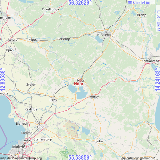
Höör GPS coordinates[2]
55° 56' 3.984" North, 13° 32' 18.6" East
| Map corner | latitude | longitude |
|---|---|---|
| Upper-left | 56.32629°, | 12.83538° |
| Center: | 55.93444°, | 13.5385° |
| Lower-right: | 55.53859°, | 14.24163° |
| Map W x H: | 87.6×87.6 km | = 54.4×54.4mi |
| max Lat: | 67.85572° ⇑93.4% North |
| Höör: | 55.93444° |
| min Lat: | ⇓6.6% South 55.34337° |
| min Long | Höör | max Long |
| 11.1712° | 13.5385° | 24.13676° |
| W 29.5%⇐ | ⇒70.5% E |
Elevation
Elevation of Höör is 81 m = 266 ft, and this is 1.6 m = 5 ft below average elevation for this country.
| Max E: |
663 m = 2175 ft | 35.4% |
| Avg. | 82.6 m = 271 ft | |
| Höör | 81 m = 266 ft | |
Min E: |
-1 m = -3 ft | 64.6% |
See also: Sweden elevation on elevation.city.
Geographical zone
Höör is located in North temperate zone (between Tropic of Cancer and the Arctic Circle). Distance of this North polar circle is 1181.8 km =734.3 mi to North.| Distance of | km | miles | from Höör |
|---|---|---|---|
| North Pole | 3787.7 | 2353.6 | to North |
| Arctic Circle | 1181.8 | 734.3 | to North |
| Tropic Cancer | 3613.4 | 2245.3 | to South |
| Equator | 6219.3 | 3864.5 | to South |


Nearby cities:
15 places around Höör: (largest is in red/bold)
• Eslöv
18.1 km =11.2 mi,  234°
234°
• Flyinge
22.8 km =14.2 mi,  208°
208°
• Harlösa
24.2 km =15 mi,  181°
181°
• Hörby
11.9 km =7.4 mi,  140°
140°
• Ljungbyhed
24.2 km =15 mi,  309°
309°
• Ludvigsborg
5.4 km =3.4 mi,  134°
134°
• Löberöd
17.6 km =10.9 mi, 182°
• Perstorp
24.4 km =15.2 mi,  338°
338°
• Röstånga
17.5 km =10.9 mi,  294°
294°
• Stehag
9.6 km =6 mi,  247°
247°
• Sätofta
2.1 km =1.3 mi,  160°
160°
• Sösdala
14.6 km =9.1 mi,  36°
36°
• Tjörnarp
8.8 km =5.5 mi, 39°
• Tormestorp
23.7 km =14.7 mi,  32°
32°
• Tyringe
25.4 km =15.8 mi,  8°
8°
Sources, notices
• [Note1] Compared only with cities in Sweden existing in our database
• [Src1] Map data: © OpenStreetMap contributors (CC-BY-SA)
• [Src2] Other city data from geonames.org with taken over terms of usage.
• [Src3] Geographical zone / Annual Mean Temperature by Robert A. Rohde @ Wikipedia
