Enköping geodata
Enköping (Uppsala) is a seat of a second-order administrative division; located in Sweden in Europe/Stockholm (GMT+2) time zone. With population of 22,553 people, there are 73 cities with bigger population in this country. Compared to other cities in Sweden, 69.2% of cities are located further ↓South; 75% of cities are located further ←West and 80.1% of cities have higher elevation than Enköping. Note1


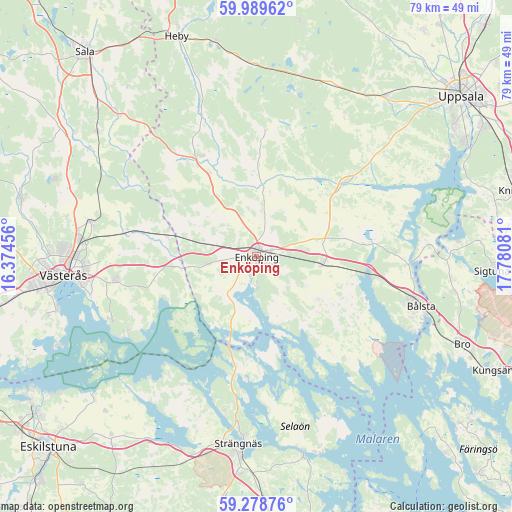
Enköping GPS coordinates[2]
59° 38' 9.852" North, 17° 4' 39.648" East
| Map corner | latitude | longitude |
|---|---|---|
| Upper-left | 59.98962°, | 16.37456° |
| Center: | 59.63607°, | 17.07768° |
| Lower-right: | 59.27876°, | 17.78081° |
| Map W x H: | 79×79 km | = 49.1×49.1mi |
| max Lat: | 67.85572° ⇑30.8% North |
| Enköping: | 59.63607° |
| min Lat: | ⇓69.2% South 55.34337° |
| min Long | Enköping | max Long |
| 11.1712° | 17.07768° | 24.13676° |
| W 75%⇐ | ⇒25% E |
Elevation
Elevation of Enköping is 16 m = 52 ft, and this is 66.6 m = 219 ft below average elevation for this country.
| Max E: |
663 m = 2175 ft | 80.1% |
| Avg. | 82.6 m = 271 ft | |
| Enköping | 16 m = 52 ft | |
Min E: |
-1 m = -3 ft | 19.9% |
See also: Sweden elevation on elevation.city.
Geographical zone
Enköping is located in North temperate zone (between Tropic of Cancer and the Arctic Circle). Distance of this North polar circle is 770.3 km =478.6 mi to North.| Distance of | km | miles | from Enköping |
|---|---|---|---|
| North Pole | 3376.2 | 2097.9 | to North |
| Arctic Circle | 770.3 | 478.6 | to North |
| Tropic Cancer | 4025 | 2501 | to South |
| Equator | 6630.9 | 4120.2 | to South |


Nearby cities:
15 places around Enköping: (largest is in red/bold)
• Bredsand
5.9 km =3.7 mi,  186°
186°
• Bålsta
26.5 km =16.5 mi,  106°
106°
• Fjärdhundra
17.8 km =11.1 mi,  330°
330°
• Grillby
10.2 km =6.3 mi,  96°
96°
• Hagby
24.4 km =15.2 mi,  41°
41°
• Hummelsta
7.6 km =4.7 mi,  262°
262°
• Hökåsen
28 km =17.4 mi,  276°
276°
• Irsta
10.8 km =6.7 mi,  311°
311°
• Irsta
21.6 km =13.4 mi, 259°
• Järlåsa
28.3 km =17.6 mi,  13°
13°
• Råby
26.4 km =16.4 mi,  115°
115°
• Strängnäs
28.9 km =18 mi, 185°
• Tillberga
26.4 km =16.4 mi, 281°
• Vittinge
29.4 km =18.3 mi,  358°
358°
• Örsundsbro
16.5 km =10.3 mi,  49°
49°
Sources, notices
• [Note1] Compared only with cities in Sweden existing in our database
• [Src1] Map data: © OpenStreetMap contributors (CC-BY-SA)
• [Src2] Other city data from geonames.org with taken over terms of usage.
• [Src3] Geographical zone / Annual Mean Temperature by Robert A. Rohde @ Wikipedia
