Sala geodata
Sala (Västmanland) is a seat of a second-order administrative division; located in Sweden in Europe/Stockholm (GMT+2) time zone. With population of 13,087 people, there are 118 cities with bigger population in this country. Compared to other cities in Sweden, 72.7% of cities are located further ↓South; 70.3% of cities are located further ←West and 56.2% of cities have lower elevation than Sala. Note1


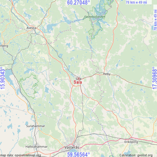
Sala GPS coordinates[2]
59° 55' 11.748" North, 16° 36' 23.58" East
| Map corner | latitude | longitude |
|---|---|---|
| Upper-left | 60.27048°, | 15.90343° |
| Center: | 59.91993°, | 16.60655° |
| Lower-right: | 59.56564°, | 17.30968° |
| Map W x H: | 78.4×78.4 km | = 48.7×48.7mi |
| max Lat: | 67.85572° ⇑27.3% North |
| Sala: | 59.91993° |
| min Lat: | ⇓72.7% South 55.34337° |
| min Long | Sala | max Long |
| 11.1712° | 16.60655° | 24.13676° |
| W 70.3%⇐ | ⇒29.7% E |
Elevation
Elevation of Sala is 62 m = 203 ft, and this is 20.6 m = 68 ft below average elevation for this country.
| Max E: |
663 m = 2175 ft | 43.8% |
| Avg. | 82.6 m = 271 ft | |
| Sala | 62 m = 203 ft | |
Min E: |
-1 m = -3 ft | 56.2% |
See also: Sweden elevation on elevation.city.
Geographical zone
Sala is located in North temperate zone (between Tropic of Cancer and the Arctic Circle). Distance of this North polar circle is 738.7 km =459 mi to North.| Distance of | km | miles | from Sala |
|---|---|---|---|
| North Pole | 3344.6 | 2078.2 | to North |
| Arctic Circle | 738.7 | 459 | to North |
| Tropic Cancer | 4056.6 | 2520.7 | to South |
| Equator | 6662.5 | 4139.9 | to South |


Nearby cities:
15 places around Sala: (largest is in red/bold)
• Fjärdhundra
23.8 km =14.8 mi,  132°
132°
• Heby
14.4 km =8.9 mi,  81°
81°
• Hökåsen
28.2 km =17.5 mi,  182°
182°
• Irsta
30.5 km =19 mi,  143°
143°
• Morgongåva
20 km =12.4 mi,  85°
85°
• Ramnäs
28.4 km =17.6 mi,  233°
233°
• Ransta
12.3 km =7.6 mi,  171°
171°
• Råby
24.1 km =15 mi,  326°
326°
• Sjövik
30.2 km =18.8 mi, 327°
• Skultuna
25 km =15.5 mi,  205°
205°
• Surahammar
32 km =19.9 mi,  222°
222°
• Tillberga
26.3 km =16.3 mi, 178°
• Tärnsjö
31.4 km =19.5 mi,  35°
35°
• Vittinge
25.7 km =16 mi, 94°
• Västerfärnebo
18.5 km =11.5 mi,  279°
279°
Sources, notices
• [Note1] Compared only with cities in Sweden existing in our database
• [Src1] Map data: © OpenStreetMap contributors (CC-BY-SA)
• [Src2] Other city data from geonames.org with taken over terms of usage.
• [Src3] Geographical zone / Annual Mean Temperature by Robert A. Rohde @ Wikipedia
