Ransta geodata
Ransta (Västmanland) is a populated place; located in Sweden in Europe/Stockholm (GMT+2) time zone. With population of 850 people, there are 927 cities with bigger population in this country. Compared to other cities in Sweden, 71.2% of cities are located further ↓South; 70.9% of cities are located further ←West and 54% of cities have lower elevation than Ransta. Note1
Administrative division(s):
- Level 1: Västmanland
- Level 2: Sala kommun
- Level 3: Kumla
- Level 4: Kumla socken


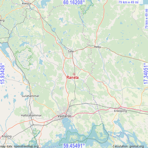
Ransta GPS coordinates[2]
59° 48' 37.332" North, 16° 38' 14.568" East
| Map corner | latitude | longitude |
|---|---|---|
| Upper-left | 60.16208°, | 15.93426° |
| Center: | 59.81037°, | 16.63738° |
| Lower-right: | 59.45491°, | 17.34051° |
| Map W x H: | 78.6×78.6 km | = 48.8×48.8mi |
| max Lat: | 67.85572° ⇑28.8% North |
| Ransta: | 59.81037° |
| min Lat: | ⇓71.2% South 55.34337° |
| min Long | Ransta | max Long |
| 11.1712° | 16.63738° | 24.13676° |
| W 70.9%⇐ | ⇒29.1% E |
Elevation
Elevation of Ransta is 57 m = 187 ft, and this is 25.6 m = 84 ft below average elevation for this country.
| Max E: |
663 m = 2175 ft | 46% |
| Avg. | 82.6 m = 271 ft | |
| Ransta | 57 m = 187 ft | |
Min E: |
-1 m = -3 ft | 54% |
See also: Sweden elevation on elevation.city.
Geographical zone
Ransta is located in North temperate zone (between Tropic of Cancer and the Arctic Circle). Distance of this North polar circle is 750.9 km =466.6 mi to North.| Distance of | km | miles | from Ransta |
|---|---|---|---|
| North Pole | 3356.8 | 2085.8 | to North |
| Arctic Circle | 750.9 | 466.6 | to North |
| Tropic Cancer | 4044.4 | 2513.1 | to South |
| Equator | 6650.3 | 4132.3 | to South |


Nearby cities:
15 places around Ransta: (largest is in red/bold)
• Fjärdhundra
16.3 km =10.1 mi,  103°
103°
• Heby
19 km =11.8 mi,  41°
41°
• Hummelsta
26.7 km =16.6 mi,  139°
139°
• Hökåsen
16.3 km =10.1 mi,  190°
190°
• Irsta
20.6 km =12.8 mi,  126°
126°
• Irsta
23.7 km =14.7 mi,  171°
171°
• Morgongåva
22.8 km =14.2 mi,  52°
52°
• Ramnäs
24.9 km =15.5 mi,  258°
258°
• Sala
12.3 km =7.6 mi,  351°
351°
• Skultuna
16.2 km =10.1 mi,  229°
229°
• Surahammar
25.9 km =16.1 mi,  243°
243°
• Tillberga
14.2 km =8.8 mi,  184°
184°
• Vittinge
26 km =16.2 mi,  67°
67°
• Västerfärnebo
25.1 km =15.6 mi,  306°
306°
• Västerås
22.1 km =13.7 mi, 192°
Sources, notices
• [Note1] Compared only with cities in Sweden existing in our database
• [Src1] Map data: © OpenStreetMap contributors (CC-BY-SA)
• [Src2] Other city data from geonames.org with taken over terms of usage.
• [Src3] Geographical zone / Annual Mean Temperature by Robert A. Rohde @ Wikipedia
