Töreboda geodata
Töreboda (Västra Götaland) is a seat of a second-order administrative division; located in Sweden in Europe/Stockholm (GMT+2) time zone. With population of 4,626 people, there are 294 cities with bigger population in this country. Compared to other cities in Sweden, 50.5% of cities are located further ↓South; 62.5% of cities are located further →East and 69.3% of cities have lower elevation than Töreboda. Note1


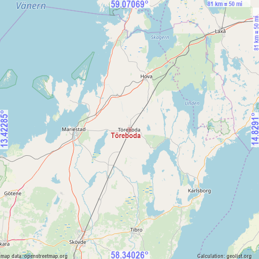
Töreboda GPS coordinates[2]
58° 42' 26.604" North, 14° 7' 33.492" East
| Map corner | latitude | longitude |
|---|---|---|
| Upper-left | 59.07069°, | 13.42285° |
| Center: | 58.70739°, | 14.12597° |
| Lower-right: | 58.34026°, | 14.8291° |
| Map W x H: | 81.2×81.2 km | = 50.5×50.5mi |
| max Lat: | 67.85572° ⇑49.5% North |
| Töreboda: | 58.70739° |
| min Lat: | ⇓50.5% South 55.34337° |
| min Long | Töreboda | max Long |
| 11.1712° | 14.12597° | 24.13676° |
| W 37.5%⇐ | ⇒62.5% E |
Elevation
Elevation of Töreboda is 96 m = 315 ft, and this is 13.4 m = 44 ft above average elevation for this country.
| Max E: |
663 m = 2175 ft | 30.7% |
| Töreboda | 96 m 315 ft | |
| Avg. | 82.6 m = 271 ft | |
Min E: |
-1 m = -3 ft | 69.3% |
See also: Sweden elevation on elevation.city.
Geographical zone
Töreboda is located in North temperate zone (between Tropic of Cancer and the Arctic Circle). Distance of this North polar circle is 873.5 km =542.8 mi to North.| Distance of | km | miles | from Töreboda |
|---|---|---|---|
| North Pole | 3479.4 | 2162 | to North |
| Arctic Circle | 873.5 | 542.8 | to North |
| Tropic Cancer | 3921.7 | 2436.8 | to South |
| Equator | 6527.6 | 4056.1 | to South |


Nearby cities:
15 places around Töreboda: (largest is in red/bold)
• Anderstorp
21.6 km =13.4 mi,  24°
24°
• Fagersanna
28.6 km =17.8 mi,  159°
159°
• Finnerödja
30.7 km =19.1 mi,  35°
35°
• Hova
17.1 km =10.6 mi, 18°
• Karlsborg
29 km =18 mi,  130°
130°
• Lugnås
25.5 km =15.8 mi,  253°
253°
• Mariestad
17.5 km =10.9 mi,  270°
270°
• Moholm
12.3 km =7.6 mi,  204°
204°
• Mölltorp
28 km =17.4 mi,  145°
145°
• Otterbäcken
27.5 km =17.1 mi,  348°
348°
• Stöpen
29.6 km =18.4 mi,  210°
210°
• Tidan
16.3 km =10.1 mi, 205°
• Timmersdala
29.1 km =18.1 mi,  228°
228°
• Ullervad
15.7 km =9.8 mi, 253°
• Väring
24.3 km =15.1 mi, 202°
Sources, notices
• [Note1] Compared only with cities in Sweden existing in our database
• [Src1] Map data: © OpenStreetMap contributors (CC-BY-SA)
• [Src2] Other city data from geonames.org with taken over terms of usage.
• [Src3] Geographical zone / Annual Mean Temperature by Robert A. Rohde @ Wikipedia
