Ullervad geodata
Ullervad (Västra Götaland) is a populated place; located in Sweden in Europe/Stockholm (GMT+2) time zone. With population of 885 people, there are 893 cities with bigger population in this country. Compared to other cities in Sweden, 50.3% of cities are located further ↑North; 65.8% of cities are located further →East and 65.3% of cities have lower elevation than Ullervad. Note1


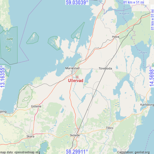
Ullervad GPS coordinates[2]
58° 40' 0.012" North, 13° 52' 0.012" East
| Map corner | latitude | longitude |
|---|---|---|
| Upper-left | 59.03039°, | 13.16355° |
| Center: | 58.66667°, | 13.86667° |
| Lower-right: | 58.29911°, | 14.5698° |
| Map W x H: | 81.3×81.3 km | = 50.5×50.5mi |
| max Lat: | 67.85572° ⇑50.3% North |
| Ullervad: | 58.66667° |
| min Lat: | ⇓49.7% South 55.34337° |
| min Long | Ullervad | max Long |
| 11.1712° | 13.86667° | 24.13676° |
| W 34.2%⇐ | ⇒65.8% E |
Elevation
Elevation of Ullervad is 84 m = 276 ft, and this is 1.4 m = 5 ft above average elevation for this country.
| Max E: |
663 m = 2175 ft | 34.7% |
| Ullervad | 84 m 276 ft | |
| Avg. | 82.6 m = 271 ft | |
Min E: |
-1 m = -3 ft | 65.3% |
See also: Sweden elevation on elevation.city.
Geographical zone
Ullervad is located in North temperate zone (between Tropic of Cancer and the Arctic Circle). Distance of this North polar circle is 878.1 km =545.6 mi to North.| Distance of | km | miles | from Ullervad |
|---|---|---|---|
| North Pole | 3483.9 | 2164.8 | to North |
| Arctic Circle | 878.1 | 545.6 | to North |
| Tropic Cancer | 3917.2 | 2434 | to South |
| Equator | 6523.1 | 4053.3 | to South |


Nearby cities:
15 places around Ullervad: (largest is in red/bold)
• Götene
26.5 km =16.5 mi,  234°
234°
• Hova
29.1 km =18.1 mi,  44°
44°
• Hällekis
25.1 km =15.6 mi,  260°
260°
• Igelstorp
30.2 km =18.8 mi,  168°
168°
• Lerdala
22.8 km =14.2 mi,  203°
203°
• Lugnås
9.9 km =6.2 mi,  254°
254°
• Mariestad
5.4 km =3.4 mi,  332°
332°
• Moholm
12 km =7.5 mi,  123°
123°
• Skövde
30.7 km =19.1 mi,  182°
182°
• Stöpen
21 km =13 mi, 180°
• Tibro
31.9 km =19.8 mi,  147°
147°
• Tidan
13 km =8.1 mi,  141°
141°
• Timmersdala
16.3 km =10.1 mi, 204°
• Töreboda
15.7 km =9.8 mi,  73°
73°
• Väring
18.9 km =11.7 mi,  161°
161°
Sources, notices
• [Note1] Compared only with cities in Sweden existing in our database
• [Src1] Map data: © OpenStreetMap contributors (CC-BY-SA)
• [Src2] Other city data from geonames.org with taken over terms of usage.
• [Src3] Geographical zone / Annual Mean Temperature by Robert A. Rohde @ Wikipedia
