Knäred geodata
Knäred (Halland) is a populated place; located in Sweden in Europe/Stockholm (GMT+2) time zone. With population of 1,211 people, there are 735 cities with bigger population in this country. Compared to other cities in Sweden, 83.9% of cities are located further ↑North; 73.9% of cities are located further →East and 58.9% of cities have lower elevation than Knäred. Note1


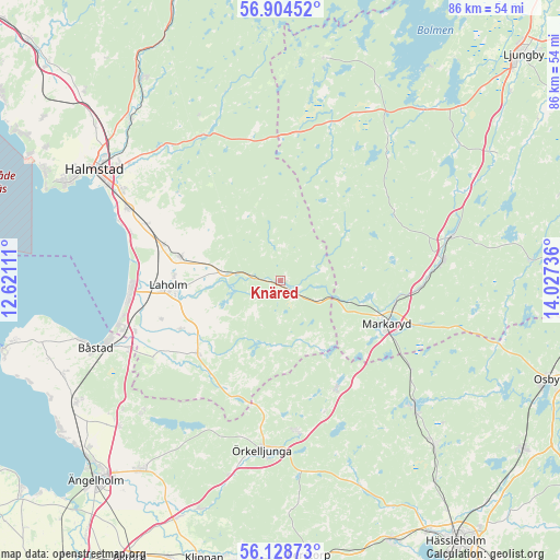
Knäred GPS coordinates[2]
56° 31' 6.996" North, 13° 19' 27.228" East
| Map corner | latitude | longitude |
|---|---|---|
| Upper-left | 56.90452°, | 12.62111° |
| Center: | 56.51861°, | 13.32423° |
| Lower-right: | 56.12873°, | 14.02736° |
| Map W x H: | 86.3×86.3 km | = 53.6×53.6mi |
| max Lat: | 67.85572° ⇑83.9% North |
| Knäred: | 56.51861° |
| min Lat: | ⇓16.1% South 55.34337° |
| min Long | Knäred | max Long |
| 11.1712° | 13.32423° | 24.13676° |
| W 26.1%⇐ | ⇒73.9% E |
Elevation
Elevation of Knäred is 67 m = 220 ft, and this is 15.6 m = 51 ft below average elevation for this country.
| Max E: |
663 m = 2175 ft | 41.1% |
| Avg. | 82.6 m = 271 ft | |
| Knäred | 67 m = 220 ft | |
Min E: |
-1 m = -3 ft | 58.9% |
See also: Sweden elevation on elevation.city.
Geographical zone
Knäred is located in North temperate zone (between Tropic of Cancer and the Arctic Circle). Distance of this North polar circle is 1116.9 km =694 mi to North.| Distance of | km | miles | from Knäred |
|---|---|---|---|
| North Pole | 3722.8 | 2313.2 | to North |
| Arctic Circle | 1116.9 | 694 | to North |
| Tropic Cancer | 3678.4 | 2285.7 | to South |
| Equator | 6284.3 | 3904.9 | to South |


Nearby cities:
15 places around Knäred: (largest is in red/bold)
• Eldsberga
21.8 km =13.5 mi,  294°
294°
• Genevad
18.8 km =11.7 mi, 287°
• Gullbranna
24.3 km =15.1 mi, 289°
• Kyrkhult
5 km =3.1 mi,  314°
314°
• Laholm
17.2 km =10.7 mi,  267°
267°
• Lilla Tjärby
16.4 km =10.2 mi, 273°
• Markaryd
17.9 km =11.1 mi,  110°
110°
• Mellbystrand
23.9 km =14.9 mi,  261°
261°
• Skottorp
23.6 km =14.7 mi,  250°
250°
• Strömsnäsbruk
24.3 km =15.1 mi,  81°
81°
• Timsfors
16.4 km =10.2 mi,  103°
103°
• Vallberga
19.7 km =12.2 mi, 252°
• Veinge
16.2 km =10.1 mi,  282°
282°
• Våxtorp
16.9 km =10.5 mi,  227°
227°
• Åsljunga
22.6 km =14 mi,  173°
173°
Sources, notices
• [Note1] Compared only with cities in Sweden existing in our database
• [Src1] Map data: © OpenStreetMap contributors (CC-BY-SA)
• [Src2] Other city data from geonames.org with taken over terms of usage.
• [Src3] Geographical zone / Annual Mean Temperature by Robert A. Rohde @ Wikipedia
