Koppom geodata
Koppom (Värmland) is a populated place; located in Sweden in Europe/Stockholm (GMT+2) time zone. With population of 669 people, there are 1099 cities with bigger population in this country. Compared to other cities in Sweden, 69.7% of cities are located further ↓South; 92.6% of cities are located further →East and 86.7% of cities have lower elevation than Koppom. Note1


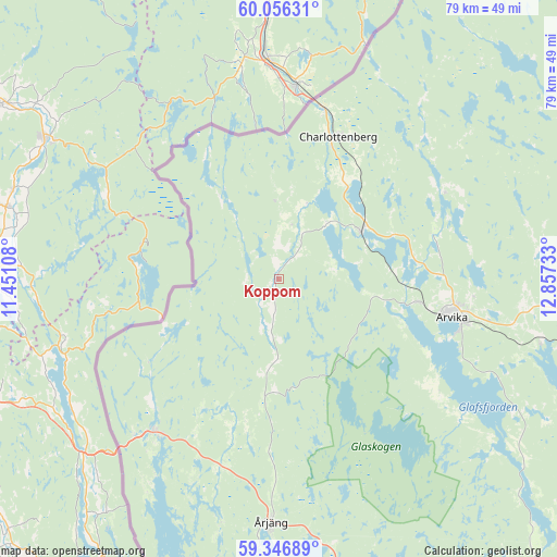
Koppom GPS coordinates[2]
59° 42' 12.528" North, 12° 9' 15.12" East
| Map corner | latitude | longitude |
|---|---|---|
| Upper-left | 60.05631°, | 11.45108° |
| Center: | 59.70348°, | 12.1542° |
| Lower-right: | 59.34689°, | 12.85733° |
| Map W x H: | 78.9×78.9 km | = 49×49mi |
| max Lat: | 67.85572° ⇑30.3% North |
| Koppom: | 59.70348° |
| min Lat: | ⇓69.7% South 55.34337° |
| min Long | Koppom | max Long |
| 11.1712° | 12.1542° | 24.13676° |
| W 7.4%⇐ | ⇒92.6% E |
Elevation
Elevation of Koppom is 176 m = 577 ft, and this is 93.4 m = 306 ft above average elevation for this country.
| Max E: |
663 m = 2175 ft | 13.3% |
| Koppom | 176 m 577 ft | |
| Avg. | 82.6 m = 271 ft | |
Min E: |
-1 m = -3 ft | 86.7% |
See also: Sweden elevation on elevation.city.
Geographical zone
Koppom is located in North temperate zone (between Tropic of Cancer and the Arctic Circle). Distance of this North polar circle is 762.8 km =474 mi to North.| Distance of | km | miles | from Koppom |
|---|---|---|---|
| North Pole | 3368.7 | 2093.2 | to North |
| Arctic Circle | 762.8 | 474 | to North |
| Tropic Cancer | 4032.5 | 2505.7 | to South |
| Equator | 6638.4 | 4124.9 | to South |


Nearby cities:
15 places around Koppom: (largest is in red/bold)
• Arvika
24.8 km =15.4 mi,  102°
102°
• Charlottenberg
21.8 km =13.5 mi,  22°
22°
• Edane
38.6 km =24 mi, 102°
• Edsvalla
66.5 km =41.3 mi,  116°
116°
• Grums
66.7 km =41.4 mi,  125°
125°
• Gärsnäs
52.7 km =32.7 mi, 127°
• Högsäter
23.8 km =14.8 mi,  336°
336°
• Jössefors
19.9 km =12.4 mi, 99°
• Slottsbron
68.2 km =42.4 mi, 128°
• Sunne
57.3 km =35.6 mi,  74°
74°
• Torsby
67.6 km =42 mi,  44°
44°
• Töcksfors
27.8 km =17.3 mi,  218°
218°
• Vålberg
67.7 km =42.1 mi, 120°
• Åmotfors
13.3 km =8.3 mi,  60°
60°
• Årjäng
34.6 km =21.5 mi,  181°
181°
Sources, notices
• [Note1] Compared only with cities in Sweden existing in our database
• [Src1] Map data: © OpenStreetMap contributors (CC-BY-SA)
• [Src2] Other city data from geonames.org with taken over terms of usage.
• [Src3] Geographical zone / Annual Mean Temperature by Robert A. Rohde @ Wikipedia
