Charlottenberg geodata
Charlottenberg (Värmland) is a seat of a second-order administrative division; located in Sweden in Europe/Stockholm (GMT+2) time zone. With population of 2,368 people, there are 472 cities with bigger population in this country. Compared to other cities in Sweden, 72.1% of cities are located further ↓South; 90.6% of cities are located further →East and 78% of cities have lower elevation than Charlottenberg. Note1


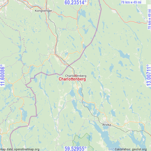
Charlottenberg GPS coordinates[2]
59° 53' 3.192" North, 12° 18' 14.328" East
| Map corner | latitude | longitude |
|---|---|---|
| Upper-left | 60.23514°, | 11.60086° |
| Center: | 59.88422°, | 12.30398° |
| Lower-right: | 59.52955°, | 13.00711° |
| Map W x H: | 78.5×78.5 km | = 48.8×48.8mi |
| max Lat: | 67.85572° ⇑27.9% North |
| Charlottenberg: | 59.88422° |
| min Lat: | ⇓72.1% South 55.34337° |
| min Long | Charlottenberg | max Long |
| 11.1712° | 12.30398° | 24.13676° |
| W 9.4%⇐ | ⇒90.6% E |
Elevation
Elevation of Charlottenberg is 134 m = 440 ft, and this is 51.4 m = 169 ft above average elevation for this country.
| Max E: |
663 m = 2175 ft | 22% |
| Charlottenberg | 134 m 440 ft | |
| Avg. | 82.6 m = 271 ft | |
Min E: |
-1 m = -3 ft | 78% |
See also: Sweden elevation on elevation.city.
Geographical zone
Charlottenberg is located in North temperate zone (between Tropic of Cancer and the Arctic Circle). Distance of this North polar circle is 742.7 km =461.5 mi to North.| Distance of | km | miles | from Charlottenberg |
|---|---|---|---|
| North Pole | 3348.6 | 2080.7 | to North |
| Arctic Circle | 742.7 | 461.5 | to North |
| Tropic Cancer | 4052.6 | 2518.2 | to South |
| Equator | 6658.5 | 4137.4 | to South |


Nearby cities:
15 places around Charlottenberg: (largest is in red/bold)
• Arvika
29.9 km =18.6 mi,  148°
148°
• Deje
72.5 km =45 mi,  115°
115°
• Edane
40.7 km =25.3 mi,  134°
134°
• Edsvalla
71.3 km =44.3 mi, 134°
• Gärsnäs
61.8 km =38.4 mi, 147°
• Högsäter
18 km =11.2 mi,  275°
275°
• Jössefors
26 km =16.2 mi, 154°
• Kil
70.8 km =44 mi, 126°
• Koppom
21.8 km =13.5 mi,  202°
202°
• Munkfors
69.4 km =43.1 mi,  94°
94°
• Sunne
47.1 km =29.3 mi,  96°
96°
• Torsby
48.1 km =29.9 mi,  54°
54°
• Töcksfors
49.1 km =30.5 mi,  211°
211°
• Åmotfors
14 km =8.7 mi,  166°
166°
• Årjäng
55.5 km =34.5 mi,  189°
189°
Sources, notices
• [Note1] Compared only with cities in Sweden existing in our database
• [Src1] Map data: © OpenStreetMap contributors (CC-BY-SA)
• [Src2] Other city data from geonames.org with taken over terms of usage.
• [Src3] Geographical zone / Annual Mean Temperature by Robert A. Rohde @ Wikipedia
