Åmotfors geodata
Åmotfors (Värmland) is a populated place; located in Sweden in Europe/Stockholm (GMT+2) time zone. With population of 1,347 people, there are 697 cities with bigger population in this country. Compared to other cities in Sweden, 70.6% of cities are located further ↓South; 89.6% of cities are located further →East and 66.2% of cities have lower elevation than Åmotfors. Note1


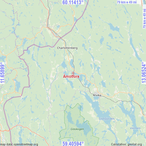
Åmotfors GPS coordinates[2]
59° 45' 42.876" North, 12° 21' 43.596" East
| Map corner | latitude | longitude |
|---|---|---|
| Upper-left | 60.11413°, | 11.65899° |
| Center: | 59.76191°, | 12.36211° |
| Lower-right: | 59.40594°, | 13.06524° |
| Map W x H: | 78.7×78.7 km | = 48.9×48.9mi |
| max Lat: | 67.85572° ⇑29.4% North |
| Åmotfors: | 59.76191° |
| min Lat: | ⇓70.6% South 55.34337° |
| min Long | Åmotfors | max Long |
| 11.1712° | 12.36211° | 24.13676° |
| W 10.4%⇐ | ⇒89.6% E |
Elevation
Elevation of Åmotfors is 87 m = 285 ft, and this is 4.4 m = 14 ft above average elevation for this country.
| Max E: |
663 m = 2175 ft | 33.8% |
| Åmotfors | 87 m 285 ft | |
| Avg. | 82.6 m = 271 ft | |
Min E: |
-1 m = -3 ft | 66.2% |
See also: Sweden elevation on elevation.city.
Geographical zone
Åmotfors is located in North temperate zone (between Tropic of Cancer and the Arctic Circle). Distance of this North polar circle is 756.3 km =469.9 mi to North.| Distance of | km | miles | from Åmotfors |
|---|---|---|---|
| North Pole | 3362.2 | 2089.2 | to North |
| Arctic Circle | 756.3 | 469.9 | to North |
| Tropic Cancer | 4039 | 2509.7 | to South |
| Equator | 6644.9 | 4128.9 | to South |


Nearby cities:
15 places around Åmotfors: (largest is in red/bold)
• Arvika
17.2 km =10.7 mi,  133°
133°
• Charlottenberg
14 km =8.7 mi,  346°
346°
• Edane
29.9 km =18.6 mi,  119°
119°
• Edsvalla
59.9 km =37.2 mi, 127°
• Grums
62.2 km =38.6 mi,  137°
137°
• Gärsnäs
48.9 km =30.4 mi, 141°
• Högsäter
26.1 km =16.2 mi,  305°
305°
• Jössefors
12.7 km =7.9 mi, 141°
• Kil
60.7 km =37.7 mi, 118°
• Koppom
13.3 km =8.3 mi,  240°
240°
• Sunne
44.5 km =27.7 mi,  79°
79°
• Torsby
54.9 km =34.1 mi,  40°
40°
• Töcksfors
40.5 km =25.2 mi,  225°
225°
• Vålberg
62.1 km =38.6 mi, 131°
• Årjäng
43.1 km =26.8 mi,  197°
197°
Sources, notices
• [Note1] Compared only with cities in Sweden existing in our database
• [Src1] Map data: © OpenStreetMap contributors (CC-BY-SA)
• [Src2] Other city data from geonames.org with taken over terms of usage.
• [Src3] Geographical zone / Annual Mean Temperature by Robert A. Rohde @ Wikipedia
