Irsta geodata
Irsta (Västmanland) is a populated place; located in Sweden in Europe/Stockholm (GMT+2) time zone. With population of 2,809 people, there are 424 cities with bigger population in this country. Compared to other cities in Sweden, 68.1% of cities are located further ↓South; 71.4% of cities are located further ←West and 72.8% of cities have higher elevation than Irsta. Note1


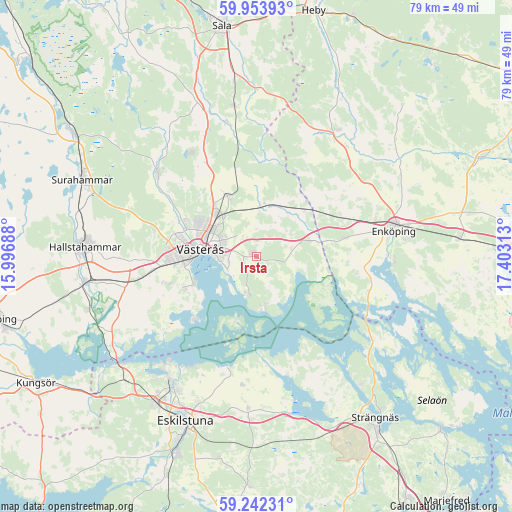
Irsta GPS coordinates[2]
59° 36' 0" North, 16° 42' 0" East
| Map corner | latitude | longitude |
|---|---|---|
| Upper-left | 59.95393°, | 15.99688° |
| Center: | 59.6°, | 16.7° |
| Lower-right: | 59.24231°, | 17.40313° |
| Map W x H: | 79.1×79.1 km | = 49.2×49.2mi |
| max Lat: | 67.85572° ⇑31.9% North |
| Irsta: | 59.6° |
| min Lat: | ⇓68.1% South 55.34337° |
| min Long | Irsta | max Long |
| 11.1712° | 16.7° | 24.13676° |
| W 71.4%⇐ | ⇒28.6% E |
Elevation
Elevation of Irsta is 22 m = 72 ft, and this is 60.6 m = 199 ft below average elevation for this country.
| Max E: |
663 m = 2175 ft | 72.8% |
| Avg. | 82.6 m = 271 ft | |
| Irsta | 22 m = 72 ft | |
Min E: |
-1 m = -3 ft | 27.2% |
See also: Sweden elevation on elevation.city.
Geographical zone
Irsta is located in North temperate zone (between Tropic of Cancer and the Arctic Circle). Distance of this North polar circle is 774.3 km =481.1 mi to North.| Distance of | km | miles | from Irsta |
|---|---|---|---|
| North Pole | 3380.2 | 2100.4 | to North |
| Arctic Circle | 774.3 | 481.1 | to North |
| Tropic Cancer | 4021 | 2498.5 | to South |
| Equator | 6626.9 | 4117.8 | to South |


Nearby cities:
15 places around Irsta: (largest is in red/bold)
• Barkarö
12.2 km =7.6 mi,  242°
242°
• Bredsand
20.7 km =12.9 mi,  95°
95°
• Dingtuna
17.9 km =11.1 mi,  260°
260°
• Enhagen-Ekbacken
10.3 km =6.4 mi,  248°
248°
• Enköping
21.6 km =13.4 mi,  79°
79°
• Fjärdhundra
23.1 km =14.4 mi,  32°
32°
• Hummelsta
14 km =8.7 mi, 77°
• Hökåsen
9.9 km =6.2 mi,  318°
318°
• Irsta
17.2 km =10.7 mi,  49°
49°
• Kjulaås
24.2 km =15 mi,  184°
184°
• Ransta
23.7 km =14.7 mi,  351°
351°
• Skultuna
20.5 km =12.7 mi,  309°
309°
• Tillberga
10.4 km =6.5 mi,  333°
333°
• Torshälla
24.3 km =15.1 mi,  212°
212°
• Västerås
8.5 km =5.3 mi,  282°
282°
Sources, notices
• [Note1] Compared only with cities in Sweden existing in our database
• [Src1] Map data: © OpenStreetMap contributors (CC-BY-SA)
• [Src2] Other city data from geonames.org with taken over terms of usage.
• [Src3] Geographical zone / Annual Mean Temperature by Robert A. Rohde @ Wikipedia
