Killeberg geodata
Killeberg (Skåne) is a populated place; located in Sweden in Europe/Stockholm (GMT+2) time zone. With population of 596 people, there are 1180 cities with bigger population in this country. Compared to other cities in Sweden, 84.2% of cities are located further ↑North; 63% of cities are located further →East and 79.1% of cities have lower elevation than Killeberg. Note1
Administrative division(s):
- Level 1: Skåne
- Level 2: Osby kommun
- Level 3: Loshult
- Level 4: Loshult socken


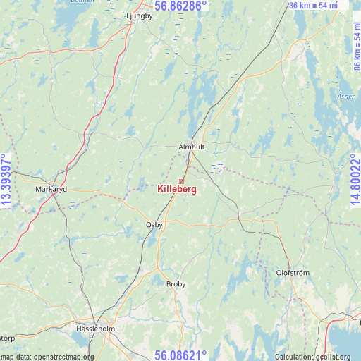
Killeberg GPS coordinates[2]
56° 28' 35.472" North, 14° 5' 49.524" East
| Map corner | latitude | longitude |
|---|---|---|
| Upper-left | 56.86286°, | 13.39397° |
| Center: | 56.47652°, | 14.09709° |
| Lower-right: | 56.08621°, | 14.80022° |
| Map W x H: | 86.4×86.4 km | = 53.7×53.7mi |
| max Lat: | 67.85572° ⇑84.2% North |
| Killeberg: | 56.47652° |
| min Lat: | ⇓15.8% South 55.34337° |
| min Long | Killeberg | max Long |
| 11.1712° | 14.09709° | 24.13676° |
| W 37%⇐ | ⇒63% E |
Elevation
Elevation of Killeberg is 140 m = 459 ft, and this is 57.4 m = 188 ft above average elevation for this country.
| Max E: |
663 m = 2175 ft | 20.9% |
| Killeberg | 140 m 459 ft | |
| Avg. | 82.6 m = 271 ft | |
Min E: |
-1 m = -3 ft | 79.1% |
See also: Sweden elevation on elevation.city.
Geographical zone
Killeberg is located in North temperate zone (between Tropic of Cancer and the Arctic Circle). Distance of this North polar circle is 1121.6 km =696.9 mi to North.| Distance of | km | miles | from Killeberg |
|---|---|---|---|
| North Pole | 3727.5 | 2316.2 | to North |
| Arctic Circle | 1121.6 | 696.9 | to North |
| Tropic Cancer | 3673.7 | 2282.7 | to South |
| Equator | 6279.6 | 3902 | to South |


Nearby cities:
15 places around Killeberg: (largest is in red/bold)
• Broby
24.6 km =15.3 mi,  182°
182°
• Diö
18.9 km =11.7 mi,  22°
22°
• Glimåkra
19.8 km =12.3 mi,  173°
173°
• Hittarp
21.5 km =13.4 mi, 176°
• Hästveda
23.5 km =14.6 mi,  205°
205°
• Liatorp
23.6 km =14.7 mi,  26°
26°
• Lönsboda
16 km =9.9 mi,  122°
122°
• Markaryd
30.8 km =19.1 mi,  266°
266°
• Osby
12.3 km =7.6 mi, 211°
• Sibbhult
24.2 km =15 mi,  164°
164°
• Sjörröd
24.2 km =15 mi, 207°
• Strömsnäsbruk
24.7 km =15.3 mi,  289°
289°
• Traryd
24.2 km =15 mi,  298°
298°
• Vittsjö
30.6 km =19 mi,  241°
241°
• Älmhult
8.7 km =5.4 mi, 16°
Sources, notices
• [Note1] Compared only with cities in Sweden existing in our database
• [Src1] Map data: © OpenStreetMap contributors (CC-BY-SA)
• [Src2] Other city data from geonames.org with taken over terms of usage.
• [Src3] Geographical zone / Annual Mean Temperature by Robert A. Rohde @ Wikipedia
