Karlholmsbruk geodata
Karlholmsbruk (Uppsala) is a populated place; located in Sweden in Europe/Stockholm (GMT+2) time zone. With population of 1,193 people, there are 747 cities with bigger population in this country. Compared to other cities in Sweden, 78.8% of cities are located further ↓South; 80.7% of cities are located further ←West and 91.5% of cities have higher elevation than Karlholmsbruk. Note1


Karlholmsbruk GPS coordinates[2]
60° 31' 15.276" North, 17° 37' 53.472" East
| Map corner | latitude | longitude |
|---|---|---|
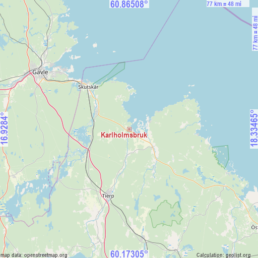
| Upper-left | 60.86508°, | 16.9284° |
| Center: | 60.52091°, | 17.63152° |
| Lower-right: | 60.17305°, | 18.33465° |
| Map W x H: | 76.9×76.9 km | = 47.8×47.8mi |
| max Lat: | 67.85572° ⇑21.2% North |
| Karlholmsbruk: | 60.52091° |
| min Lat: | ⇓78.8% South 55.34337° |
| min Long | Karlholmsbruk | max Long |
| 11.1712° | 17.63152° | 24.13676° |
| W 80.7%⇐ | ⇒19.3% E |
Elevation
Elevation of Karlholmsbruk is 8 m = 26 ft, and this is 74.6 m = 245 ft below average elevation for this country.
| Max E: |
663 m = 2175 ft | 91.5% |
| Avg. | 82.6 m = 271 ft | |
| Karlholmsbruk | 8 m = 26 ft | |
Min E: |
-1 m = -3 ft | 8.5% |
See also: Sweden elevation on elevation.city.
Geographical zone
Karlholmsbruk is located in North temperate zone (between Tropic of Cancer and the Arctic Circle). Distance of this North polar circle is 671.9 km =417.5 mi to North.| Distance of | km | miles | from Karlholmsbruk |
|---|---|---|---|
| North Pole | 3277.8 | 2036.7 | to North |
| Arctic Circle | 671.9 | 417.5 | to North |
| Tropic Cancer | 4123.4 | 2562.2 | to South |
| Equator | 6729.3 | 4181.4 | to South |


Nearby cities:
15 places around Karlholmsbruk: (largest is in red/bold)
• Björke
36.1 km =22.4 mi,  319°
319°
• Bönan
29.9 km =18.6 mi, 324°
• Forsby
34.8 km =21.6 mi,  308°
308°
• Furuvik
21.7 km =13.5 mi, 311°
• Gävle
31.7 km =19.7 mi,  302°
302°
• Månkarbo
33.8 km =21 mi,  195°
195°
• Skutskär
16.5 km =10.3 mi, 314°
• Skärplinge
9.5 km =5.9 mi,  129°
129°
• Söderfors
26.7 km =16.6 mi,  234°
234°
• Tierp
20.8 km =12.9 mi, 197°
• Tobo
29.2 km =18.1 mi,  177°
177°
• Valbo
35.7 km =22.2 mi,  293°
293°
• Älvkarleby
11.4 km =7.1 mi, 299°
• Åbyggeby
36.7 km =22.8 mi, 310°
• Örbyhus
33.2 km =20.6 mi,  173°
173°
Sources, notices
• [Note1] Compared only with cities in Sweden existing in our database
• [Src1] Map data: © OpenStreetMap contributors (CC-BY-SA)
• [Src2] Other city data from geonames.org with taken over terms of usage.
• [Src3] Geographical zone / Annual Mean Temperature by Robert A. Rohde @ Wikipedia
