Söderfors geodata
Söderfors (Uppsala) is a populated place; located in Sweden in Europe/Stockholm (GMT+2) time zone. With population of 1,704 people, there are 594 cities with bigger population in this country. Compared to other cities in Sweden, 77.4% of cities are located further ↓South; 77% of cities are located further ←West and 68.9% of cities have higher elevation than Söderfors. Note1


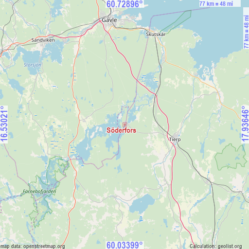
Söderfors GPS coordinates[2]
60° 22' 59.988" North, 17° 13' 59.988" East
| Map corner | latitude | longitude |
|---|---|---|
| Upper-left | 60.72896°, | 16.53021° |
| Center: | 60.38333°, | 17.23333° |
| Lower-right: | 60.03399°, | 17.93646° |
| Map W x H: | 77.3×77.3 km | = 48×48mi |
| max Lat: | 67.85572° ⇑22.6% North |
| Söderfors: | 60.38333° |
| min Lat: | ⇓77.4% South 55.34337° |
| min Long | Söderfors | max Long |
| 11.1712° | 17.23333° | 24.13676° |
| W 77%⇐ | ⇒23% E |
Elevation
Elevation of Söderfors is 26 m = 85 ft, and this is 56.6 m = 186 ft below average elevation for this country.
| Max E: |
663 m = 2175 ft | 68.9% |
| Avg. | 82.6 m = 271 ft | |
| Söderfors | 26 m = 85 ft | |
Min E: |
-1 m = -3 ft | 31.1% |
See also: Sweden elevation on elevation.city.
Geographical zone
Söderfors is located in North temperate zone (between Tropic of Cancer and the Arctic Circle). Distance of this North polar circle is 687.2 km =427 mi to North.| Distance of | km | miles | from Söderfors |
|---|---|---|---|
| North Pole | 3293.1 | 2046.2 | to North |
| Arctic Circle | 687.2 | 427 | to North |
| Tropic Cancer | 4108.1 | 2552.7 | to South |
| Equator | 6714 | 4171.9 | to South |


Nearby cities:
15 places around Söderfors: (largest is in red/bold)
• Furuvik
30.2 km =18.8 mi,  10°
10°
• Hedesunda
13 km =8.1 mi,  278°
278°
• Karlholmsbruk
26.7 km =16.6 mi,  54°
54°
• Månkarbo
21.4 km =13.3 mi,  143°
143°
• Skutskär
28.7 km =17.8 mi,  20°
20°
• Skärplinge
30.7 km =19.1 mi,  72°
72°
• Tierp
16.3 km =10.1 mi,  106°
106°
• Tobo
27.1 km =16.8 mi,  120°
120°
• Tärnsjö
30.8 km =19.1 mi,  212°
212°
• Viby
31.6 km =19.6 mi,  183°
183°
• Älvkarleby
24 km =14.9 mi,  29°
29°
• Årsunda
31.1 km =19.3 mi,  298°
298°
• Örbyhus
31.3 km =19.4 mi, 124°
• Östervåla
22.4 km =13.9 mi,  187°
187°
• Överhärde
29.8 km =18.5 mi,  330°
330°
Sources, notices
• [Note1] Compared only with cities in Sweden existing in our database
• [Src1] Map data: © OpenStreetMap contributors (CC-BY-SA)
• [Src2] Other city data from geonames.org with taken over terms of usage.
• [Src3] Geographical zone / Annual Mean Temperature by Robert A. Rohde @ Wikipedia
