Hudiksvall geodata
Hudiksvall (Gävleborg) is a seat of a second-order administrative division; located in Sweden in Europe/Stockholm (GMT+2) time zone. With population of 16,081 people, there are 99 cities with bigger population in this country. Compared to other cities in Sweden, 84.6% of cities are located further ↓South; 75.4% of cities are located further ←West and 98.2% of cities have higher elevation than Hudiksvall. Note1
Administrative division(s):
- Level 1: Gävleborg
- Level 2: Hudiksvalls Kommun
- Level 3: Hudiksvall-Idenor
- Level 4: Hudiksvall socken


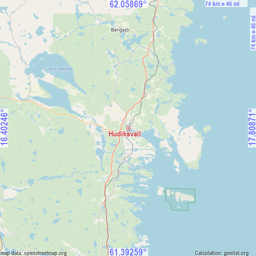
Hudiksvall GPS coordinates[2]
61° 43' 38.784" North, 17° 6' 20.088" East
| Map corner | latitude | longitude |
|---|---|---|
| Upper-left | 62.05869°, | 16.40246° |
| Center: | 61.72744°, | 17.10558° |
| Lower-right: | 61.39259°, | 17.80871° |
| Map W x H: | 74.1×74.1 km | = 46×46mi |
| max Lat: | 67.85572° ⇑15.4% North |
| Hudiksvall: | 61.72744° |
| min Lat: | ⇓84.6% South 55.34337° |
| min Long | Hudiksvall | max Long |
| 11.1712° | 17.10558° | 24.13676° |
| W 75.4%⇐ | ⇒24.6% E |
Elevation
Elevation of Hudiksvall is 2 m = 7 ft, and this is 80.6 m = 264 ft below average elevation for this country.
| Max E: |
663 m = 2175 ft | 98.2% |
| Avg. | 82.6 m = 271 ft | |
| Hudiksvall | 2 m = 7 ft | |
Min E: |
-1 m = -3 ft | 1.8% |
See also: Sweden elevation on elevation.city.
Geographical zone
Hudiksvall is located in North temperate zone (between Tropic of Cancer and the Arctic Circle). Distance of this North polar circle is 537.7 km =334.1 mi to North.| Distance of | km | miles | from Hudiksvall |
|---|---|---|---|
| North Pole | 3143.6 | 1953.3 | to North |
| Arctic Circle | 537.7 | 334.1 | to North |
| Tropic Cancer | 4257.5 | 2645.5 | to South |
| Equator | 6863.4 | 4264.7 | to South |


Nearby cities:
15 places around Hudiksvall: (largest is in red/bold)
• Arbrå
48 km =29.8 mi,  232°
232°
• Bergsjö
28.4 km =17.6 mi,  355°
355°
• Delsbo
30.1 km =18.7 mi,  285°
285°
• Enånger
20.8 km =12.9 mi,  193°
193°
• Friggesund
34.7 km =21.6 mi,  302°
302°
• Gnarp
36.6 km =22.7 mi,  12°
12°
• Harmånger
23 km =14.3 mi, 14°
• Iggesund
9.6 km =6 mi, 189°
• Järvsö
49.5 km =30.8 mi,  268°
268°
• Mohed
50.2 km =31.2 mi,  197°
197°
• Njutånger
13 km =8.1 mi, 191°
• Näsviken
13.3 km =8.3 mi, 289°
• Söderala
49.9 km =31 mi, 188°
• Söderhamn
47.2 km =29.3 mi,  182°
182°
• Sörforsa
6.5 km =4 mi,  275°
275°
Sources, notices
• [Note1] Compared only with cities in Sweden existing in our database
• [Src1] Map data: © OpenStreetMap contributors (CC-BY-SA)
• [Src2] Other city data from geonames.org with taken over terms of usage.
• [Src3] Geographical zone / Annual Mean Temperature by Robert A. Rohde @ Wikipedia
